PAST WEEK:
Monday June 13, 2022. 12:00 Hrs. + 4 Deg C with a 15-25 KPH SW wind.
Tuesday June 14, 2022. 12:00 Hrs. +4 Deg C with a 5-10 KPH West breeze.
Wednesday June 15, 2022. 12:00 Hrs. +8 Deg C with a 5-10 KPH East breeze.
Thursday June 16, 2022. 12:00 Hrs. +3 Deg C with a 10-15 KPH ESE wind.
Friday June 17, 2022. 12:00 Hrs. +6 Deg C with a 5-10 KPH ENE Breeze.
Saturday June 18 2022. 12:00 Hrs. +3 Deg C with a 10-15 KPH SW wind.
Sunday June 19, 2022. 12:00 Hrs. +4 Deg C with a 10-15 KPH SW wind.
Weather Observations for June 20, 2022 taken at 06:00 Hours.
2180 meters +2, Winds were 0-5 KPH NNW--Whistler Peak
1835 meters +2, Winds were 5-10 KPH NNE--Round House
1650 meters +3, 0.0 mm in 12 Hrs, 0.0 mm in 24 Hrs --Pig Alley
660 meters +9, Valley Temp, Max temp Yesterday was +17, 0.0 mm of precip yesterday.
Broken cloud above 2000 m this am, with unlimited visibility.
Cloud and variable visibility at 1835 m this am.
FORECAST:
Broken cloud above 2000m, with a thick stratus layer at mid mountain, but dry this am in a Northerly flow aloft. Should see some sunny breaks this afternoon as the layer lifts, at least it is dry. Freezing level is around 3000 m. Cool upper low will bring some wet weather for Tuesday afternoon with periods of light precipitation. Upper low will begin to slide east after some morning showers on Wednesday, ridge will slowly build in by Wednesday afternoon. Should see mostly sunny weather by Wednesday night. May see some cloud for Thursday but favouring the ridge to continue building, time will tell. Ridge strengthens and finally sticks around into the weekend. Looking good into early next week. Finally a stretch of summer like weather. Guesstimates: 0-trace by Tuesday am, 2-6 mm by Wednesday am, 1-4 mm by Thursday am, 0-trace by Friday am, 0 mm by Saturday am, 0 mm by Sunday am, 0 mm by Monday am.
GOES IR image from this am.
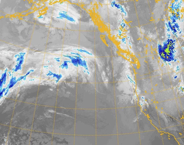
GOES 17 ABI Image 2022/06/20. 05:00 Hrs.
Still a significant amount of cloud

Northerly flow aloft.
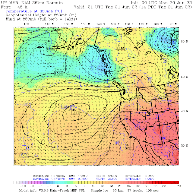
Cold upper low will bring moist weather on Tuesday.
Moisture arrives for Tuesday afternoon.
High pressure seems to be getting larger, low still just to the North. Showers in the am.
Still some moisture Wednesday am, dirty ridging by the pm.
Low moves off to the east, ridge strengthens by Thursday pm.
Looking good for Friday, sunny weather, seasonable temperatures.
High pressure continues into Saturday.
Finally some summer temperatures forecasted for the weekend.
Low to the North but hopefully the high brings sunny weather for Sunday.
AVALANCHE ACTIVITY:
Old wet lose, taken June 17, 2022.
INFORMATION & OBSERVATIONS:
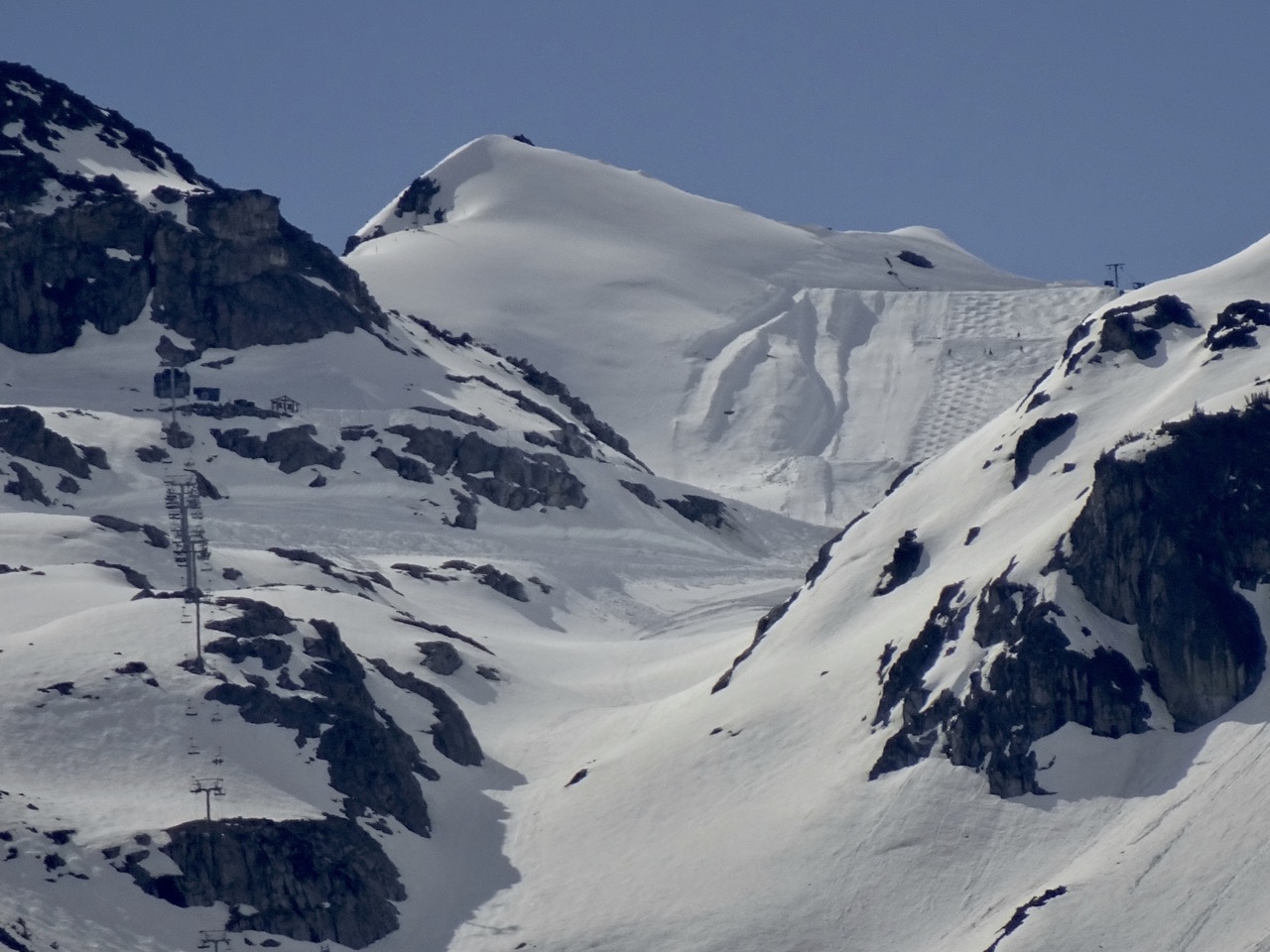
Difficult visibility on the Glacier. Monday 12:00 Hrs. Still winter in the alpine.
River of Golden Dreams. Full but not flooding on Monday. High in the valley was +17 Deg C.
Tuesday afternoon, variable visibility in the alpine. 0 Deg C at 12:00 Hrs.
Overcast but dry Wednesday, +5 Deg C, 12:00 Hrs at 2180 m.
Thursday, 12:00 Hrs. +1 Deg C.
Another unsettled day on Thursday.
Convective Puff Ball Thursday!
Friday morning, bluebird.
Awesome biking weather on Friday. 16:00 Hrs. Increase in cloud cover in the pm. + 19 Deg C.
13:00 Hrs Saturday. Started drying out.
Overcast but dry at 14:00 Hrs Saturday. +13 Deg C. 7.1 mm of rain recorded at 660 m Saturday.
Busy day in the bike park Sunday, high in the valley was +17 Deg C.
VIDEOS:
From instagram, not sure where: Avalanche
Stiff Cornice: Small Drop
Nice Air: Small Sluff
ARTICLES:
Going-to-the Sun-Road plowing slowed by significant snowfall: Montana
The avalanche was not the fault of the earthquake at Rigopiano: Italy
Avalanche forecasters train AI to help predict risk: SLF
Evan was buried in an avalanche: What was that like?
Snow hits mountain parks as avalanche risk rises: CTV News
Summer Avalanches?: Powder Canada
Rare 'Triple-Dip' La Nina could mean a wild winter ahead for Western Canada: CBC News
U.S. Motorized Avalanche Fatalities Report: Winter 21-22
Biggest snowfall in decades hits Southern Slopes: New Zealand


No comments:
Post a Comment