AVALANCHE ACTIVITY:
A small avalanche injured two hikers on Howe Sound Crest trail. Rescued by NSSar. Net Pic
An avalanche has killed 1 women, 2 missing, 2 rescued in Bajhang district. Article below. Net Pic.
No new avalanches observed on Blackcomb Sunday.
WEATHER YESTERDAY:
Sunrise Sunday was at 05:18 Hrs. +6 Deg C with a 10-20 KPH SE wind at 1860 m.
08:00 Hrs. +5 Deg C with a 5-15 KPH WSW wind at 1860 m.
10:00 Hrs. +8 Deg C with a 10-15 KPH SSW wind at 1860 m.
Sunday May 21, 2023. 12:00 Hrs. +6 deg C with a 15-25 KPH West wind at 1835 m.
14:00 Hrs. + 8 Deg C with a 5-15 KPH WNW wind at 1860 m.
16:00 Hrs. +7 Deg C with a 20-35 KPH SW wind at 2280 m.
Weather Observations for May 22, 2023 taken at 06:00 Hours.
2280 meters 0, Winds were 0-10 KPH N--Horstman Hut
1860 meters +1, Winds were 5-10 KPH N--Rendezvous
1650 meters +3, 2.3 mm in 12 Hrs, 2.3 mm in 24 Hrs. Base 122 cm--Pig Alley
1570 meters +3, 4.2 mm in 12 Hrs, 4.2 mm in 24 Hrs. Base 21 cm--Catskinner
660 meters +9, Valley Temp, Max temp Yesterday was +20.6, 0.0 mm of precip yesterday.
High yesterday at 2280 m was +7.3 Deg C at 16:00 Hrs. At 1860 m +8.4 Deg C at 17:45 Hrs.
08:45 Upload Today.
2.3 mm recorded at 1650 m by 06:00 hrs. Base 122 cm.
As of 07:00 Hrs we have overcast skies, variable visibility. Not raining.
FORECAST:
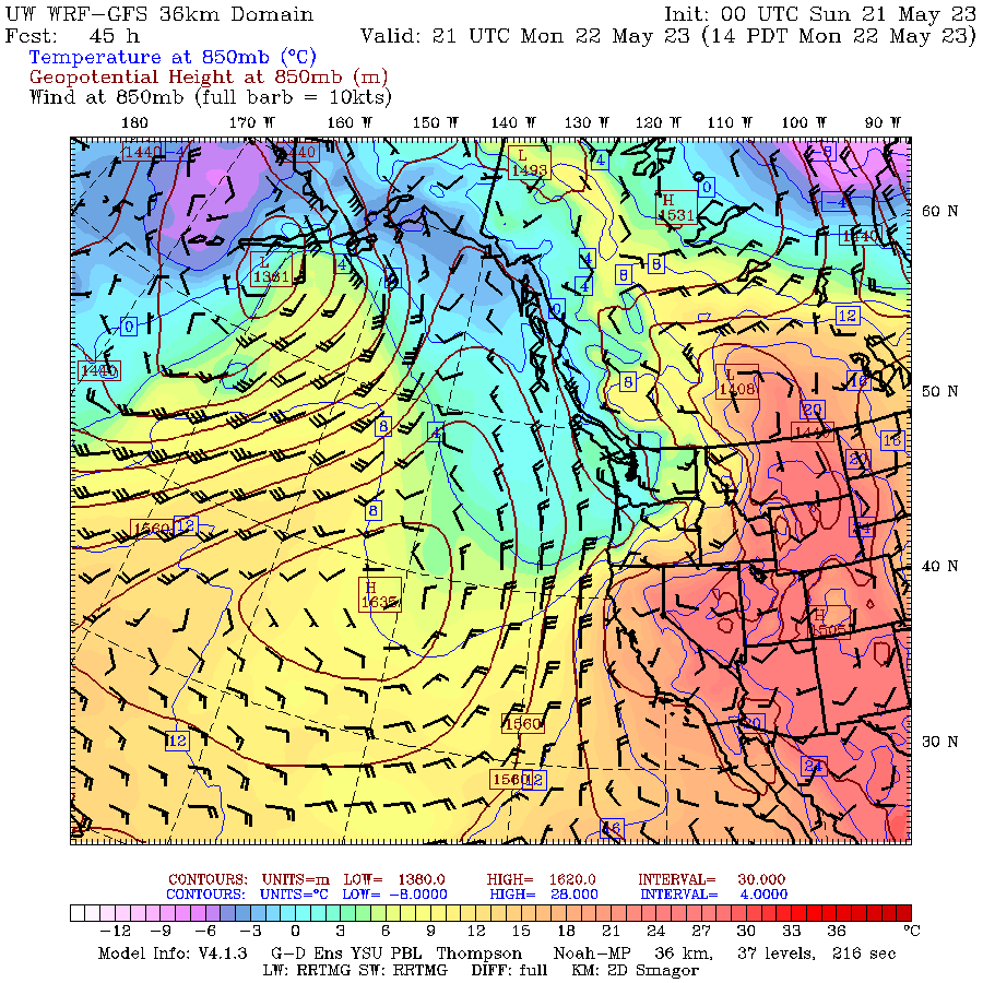
Upper level low will bring an unsettled day in a Southerly flow aloft. Mostly overcast with some possible breaks for today with showers in the mix. The FL is hovering in the 2300 m range and will likely rise to 2600 m with daytime heating. Seems some of the precipitation forecasted for today came early this am. Weak upper low lingers into Tuesday with mostly overcast skies, some breaks and periods of very light precipitation. Dirty ridging for Wednesday with a mix of sun and cloud. Ridge strengthens for Thursday with mostly sunny skies. May see some convective cloud development in the pm with a chance of some showers. Sunny skies for Friday with some clouds arriving Friday night. Dirty ridging for Saturday. Unsettled for Sunday with a mix of sun, clouds, and showers. This concludes daily updates. Will be posting on Mondays through the summer with a weekly forecast and avalanche and climate news. Thanks to all my sponsors and those who hit the donate button, much appreciated. Guesstimates: 1-3 mm by Tuesday am, 0-trace by Wednesday am, 0 mm by Thursday am, 0-trace by Friday am, 0 mm by Saturday am, 1-3 mm by Sunday am, 1-2 mm by Monday am.
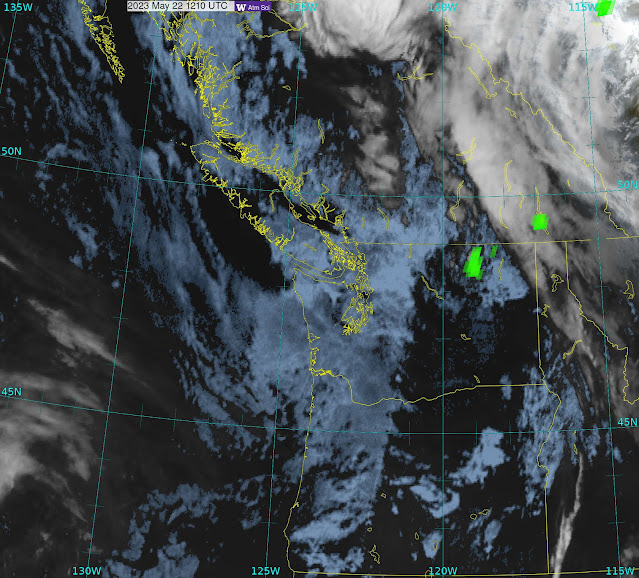
GOES VIS, IR, Lightning Image from this am.
WINDY IMAGE 2023/05/22. 05:00 Hrs.
Upper level low will bring periods of precipitation on Monday, seasonable temperatures.
.jpg)
Low brings periods of light precipitation on Monday.
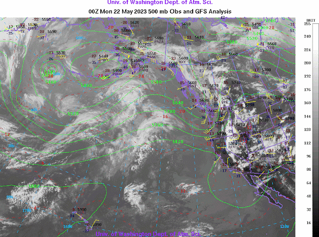
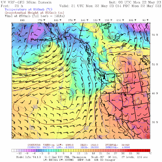
Southerly flow aloft Monday.
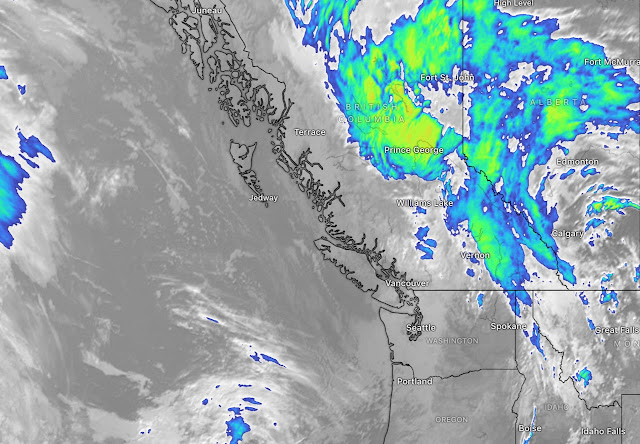
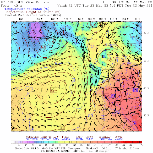 Low and associated trough will bring overcast skies and some showers Tuesday. Below avg temps.
Low moves East lingering cloud with a few showers for Tuesday.
Dirty upper ridge for Wednesday with a mix of sun and cloud. Slightly above average temps.
Dry on Wednesday with a mix of sun and cloud.
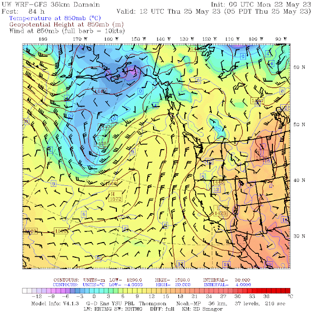
Ridge strengthens Thursday with sunny skies, possible convective cloud development in pm.
Sunny skies for Thursday.
Sunny skies most of the day Friday, cloudy in the late pm. Above verge temps.
Dirty ridging for Saturday, mix of sun and cloud. Above average temps.
Unsettled Sunday with a mix of sun and cloud with some rain showers. Above average temps.
INFORMATION AND OBSERVATIONS:
08:00 +5 Deg C with a 15-20 KPH South wind at 2280 m.
Run inspection mandatory on first lap!
Glacier Wrap! Should help unless we get another heat dome! Short summer season??!
Blackcomb Creek flow eased on Sunday, by 15 % ? !
A Lost Lake sign where Blackcomb Creek enters and exits side by side.
Cool moist cloud in the alpine Sunday am.
It is getting thin, shout out to the groomers for making it happen in difficult conditions.
The elusive Whistler Still Wood Duck!
Convective cloud development Sunday am.
Getting close to a wrap!
Cool moist clouds passing through.
Green Lake is still in flood but was a bit lower Sunday pm.
Duck Family swimming over trail.
Back of the Whistler Museum.
FROM AVALANCHE CANADA:
Backcountry Avalanche Advisory – Sea to Sky
Avalanche Canada advisories are done for the season. Advisories are typically available in fall, winter and spring (October – April). Please check back in Fall 2023 for Whistler and the Sea to Sky region advisories. If you're heading into the mountains this spring, learn more about assessing spring conditions.
LOCAL MIN REPORTS:
No new MIN reports as of 07:00 Hrs.
SHORT CLIPS:
Quad Backflip: Utah
Practice can be: Painful
The increase in: Collisions
When the snow: Runs Out
ARTICLES:
1 Dead in avalanche, 2 Yarshi pickers missing: Nepal
Two people rescued after "small avalanche' off Howe Sound Crest Trail: North Shore Rescue
More snow falls in Australia as the season approaches: PlanetSki
Spring update from the UAC: Utah Avalanche Centre
If you enjoy the content and find it useful, please hit the donate button, top right on side bar.
Send me recent avalanche images. E-Mail top right of the side bar. Read Below:
Goggle contest returning again this year, win a pair of Marker goggles for the best avalanche image for the months of April-May. Grand prize best image of the season will be a Pair of Prior Skis or a Split Board awarded at the end of May.

.jpeg)
.jpeg)
.jpeg)
.jpeg)
.jpeg)
.jpeg)
.jpeg)
.jpeg)
.jpeg)
.jpeg)
.jpeg)


.jpg)

 Low and associated trough will bring overcast skies and some showers Tuesday. Below avg temps.


 Ridge strengthens Thursday with sunny skies, possible convective cloud development in pm.


.jpeg)
.jpeg)
.jpeg)
.jpeg)
.jpeg)
.jpeg)
.jpeg)
.jpeg)
.jpeg)
.jpeg)
.jpeg)
.jpeg)
.jpeg)
.jpeg)
.jpeg)

.jpeg)
.jpeg)
.jpeg)
.jpeg)
.jpeg)
.jpeg)
.jpeg)
.jpeg)
.jpeg)
.jpeg)
.jpeg)
.jpeg)
.jpeg)
.jpeg)

.jpeg)


.jpeg)
.jpeg)
.jpeg)
.jpeg)
.jpeg)
.jpeg)
.jpeg)
.jpeg)
.jpeg)
.jpeg)
.jpeg)
.jpeg)
.jpeg)
.jpeg)