18 Apr 2015

April 18, 2015

    High thin cloud layer early Friday April 17, 2015.

    08:00 Hours Friday morning.

    Wedge Friday morning.

    Later in the morning convective cloud development brought a mix of cloud and sun.

    Some of the clouds were looking pretty dark but no precipitation in our area.

    15:00 Hours yesterday afternoon.

    Later in the afternoon the high pressure began to build with more blue than white.


Weather Observations for April 18, 2015; taken at 06:00 Hours.

2240 meters      -3, Winds were 5-10 KPH from the SSW
2180 meters       0, Winds were 10-15 KPH from the WSW
1860 meters      -1, Winds were 5-10 KPH from the S
1835 meters       0, Winds were 0-10 KPH from the ENE
1650 meters      -1, No new snow, Base 187 cm.
1550 meters       0, No new snow, Base 140 cm, Relative Humidity 60%. 
  660 meters      -1, Valley Temp, Max Temp Yesterday was +16.8.

   As of 07:00 Hours we have clear skies and unlimited visibility.

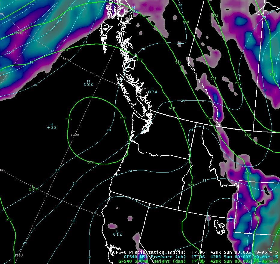
For the forecast, high pressure at the surface and aloft is centred to the Southwest of our area bringing dry warm conditions into Tuesday with a Northwesterly flow aloft. The freezing level will be well above the local peaks during this sunny period.  A weak front will move onshore on Tuesday afternoon with unsettled weather and the chance of some light rain showers in a Westerly flow. Expect typical unsettled spring conditions Wednesday and Thursday with the FL dropping back to more normal values. Low of 1500 meters to highs of 1800 meters. Get out your sun screen.

    High pressure dominating the pattern for the next few days.

    Sunny warm weather for this time of the year.

    Very warm temperatures associated with the high pressure.

    Each day it warms slightly.

    Sunny again on Monday.


ARTICLES:

Coast Mountain Backcountry Report-April 16, 2015: Escape Route

April Powder: Avalanche Canada

Integrated Seasonal Climate Bulletin: Environment Canada

Using Space Imagery to understand avalanches on Mt. Everest: SpaceRef

Warm temperatures will have an effect on the snow pack: Isothermal


   13:15 Hours yesterday afternoon.

    Big picture yesterday at 13:15.

    Sun on East facing moraine below Fissile produced some small wet avalanche activity.

    Evidence of pinwheeling over the past couple of days.

    Cloudy yesterday but still enough sun to warm up solar aspects.

    Very dry in the valley this spring!

17 Apr 2015

April 17, 2015

    Early Thursday April 16, 2015. Overcast skies.

    Less cloudy yesterday morning over the Tantalus Range.

    South of Squamish it was a nice looking day.

    By early afternoon it had significantly cleared over the Tantalus Range.

    15:30 Hours yesterday over Blackcomb.

    More clearing at 16:30 Hours.

    Nice day by 17:00 Hours.

Weather Observations for April 17, 2015; taken at 06:00 Hours.

2240 meters      -3, Winds were 30-55 KPH from the S
2180 meters      -1, Winds were 30-45 KPH from the SSW
1860 meters       0, Winds were 10-30 KPH from the SSE
1835 meters     +2, Winds were 10-40 KPH from the SSW
1650 meters     +2, No new snow, Base 192 cm.
1550 meters     +3, No new snow, Base 142 cm, Relative Humidity 65%. 
  660 meters     +3, Valley Temp, Max Temp Yesterday was +16.5.

    As of 07:00 Hours this am we have mostly overcast skies and unlimited visibility.

For the forecast, a weak upper trough and associated cold front will bring mostly cloudy conditions with some breaks in a Westerly Flow aloft today. Another day when we are on the edge of the high pressure and cloud from the low to the Northwest. We may get lucky with more sun in the valley. There is a chance of some isolated intermittent showers with the freezing level rising from 1800 meters to 2200 meters this afternoon. A strong upper ridge builds for Saturday with a Northerly flow aloft with warm temperatures into Tuesday. Another weak upper trough pushes onshore on Wednesday with cooler temperature and showery weather.

    Weak upper trough with a cold front moves through the area today.


    Strong upper ridge builds for Saturday.

    Flow will be Northerly with warm temperatures.

    Sunny on Sunday.

    Sunny on Monday.

    A weak trough moves onshore for Wednesday with cooler temperatures and showery weather.


VIDEO FRIDAYS:

When you are way over your ability: Live Leak

Quad Cork on a snowboard: Billy Morgan

A slow moving land slide: Russia

Vail's Newest patrol Dog: Jake

ARTICLES:

Bad Weather hampering mountaineers efforts on Everest: Tent Bound

Avalanche Danger rising in Colorado: Wet Snow

Weather Update: Avalanche Canada

Spring Slabs: Pistehors.com


    High pressure pushing North yesterday.

    Big picture yesterday.

    The clouds were from Squamish North.

    Tantalus Range yesterday afternoon.

    Rumbling Glacier.

    Mount Garibaldi with some cloud clinging on yesterday afternoon.

    Tantalus Range, impressive as always.

    Mount Currie later in the afternoon, Thursday April 16, 2015.

16 Apr 2015

April 16, 2015

    Sunrise Wednesday April 15, 2015. Officially at 06:19.

    High and mid mountain cloud early Wednesday morning.

    Cloudier as the morning progressed.

    Still great winter snow above 1000 meters. Grooming was superb yesterday.

    Around noon yesterday.


Weather Observations for April 16, 2015; taken at 06:00 Hours.

2240 meters      -4, Winds were 20-40 KPH from the SSE
2180 meters      -3, Winds were 20-25 KPH from the SSW
1860 meters      -2, Winds were 15-25 KPH from the E
1835 meters       0, Winds were 15-20 KPH from the S
1650 meters      -1, No new snow, Base 202 cm.
1550 meters      -1, No new snow, Base 146 cm, Relative Humidity 85%. 
  660 meters     +1, Valley Temp, Max Temp Yesterday was +10.1.


   As of 07:00 Hours we have overcast skies and unlimited visibility.


For the forecast, a warm front along the BC coast and a high pressure just Southwest of our zone will bring unsettled weather this morning in a Westerly flow aloft. The high may push the frontal band further North today allowing sunny conditions in the alpine this afternoon with the freezing level reaching 2600 meters. Low level cloud may develop in the valley. Friday will also be unsettled with a bit more moisture from the front to our North and there is a slight chance of some isolated showers Friday afternoon. The ridge builds Saturday with a Northwesterly flow aloft bringing sunny conditions to the area by the afternoon with warm temperatures into Tuesday. The flow shifts again around that time period to Southerly and we may get some unsettled conditions for Tuesday.  Fl will remain fairly high through the next few days maxing out at 3000 meters by Monday.


    On the boundary of the High and the Front.

    Some cloud around on Friday.

    Early Saturday morning. Ridge builds during the day.

    Sunny and warm Sunday.

    Sunny and warm Monday

    Clouds may move back in on Tuesday.


ARTICLES:

April Showers may bring May Flowers, but Winter Snow is water in the bank: USGS

Colorado reviews water, fire outlook as snow falls behind: Denver, CO

Avalanche experts say victim took every precaution: Montana

Whistler preparing for a dry summer: Pique


    Big picture around noon yesterday.

    Still looking like winter above 1000 meters.

    Mount Currie yesterday afternoon. Trees are budding.

    Solar induced sluffing on Mount Currie.

    Some dark clouds went through the area yesterday afternoon.

    Bufflehead Ducks.