Last weeks weather--this weeks forecast and some new articles below:
Fresh snow Tuesday September 20, 2016.
Tuesday afternoon.
Wednesday September 21, 2016--Last day of summer.
Satellite image Wednesday Morning.
Thursday morning September 22, 2016.
Thursday afternoon, some cloud development with the front just offshore.
Friday September 23, 2016--snowing +1 at 1835 meters.
Friday morning.
Quiet day Friday, 3.1 mm of rain recorded at 660 meters.
Cloudy Friday afternoon. Rain eased off.
Saturday morning.
Status layer lifted by the afternoon on Saturday.
Clouds continued to build Saturday afternoon, trace of rain recorded Saturday evening at 660 M.
Sunday September 25, 2016. Overcast +4 Deg at 07:00 Hrs.
Sunday morning, Surface high should push North by late afternoon.
Sunday September 25, Sunrise was at 07:03-Sunset at 19:03. 12 hours of day 12 hours of night.
Some breaks Sunday afternoon, despite the morning drizzle only 0.3 mm of rain recorded at 660 M.
Early Monday morning September 26, 2016.
Monday afternoon cloudy with showers. 1.1 mm of rain recorded at 660 meters.
Weather Observations for September 27, 2016: taken at 07:00 Hours.
2180 meters 0, Winds were 5-10 KPH WSW --Whistler Peak
1835 meters +3, Winds were 5-10 KPH S --Roundhouse
1550 meters +5, RH 86% 0.7 mm of rain this am --Catskinner
660 meters +9, Valley Temp, Max Temp Yesterday was +14.6 1.1 mm of Precip recorded yest
As of 07:00 hrs this am we have scattered high cloud, variable visibility and a valley stratus layer.
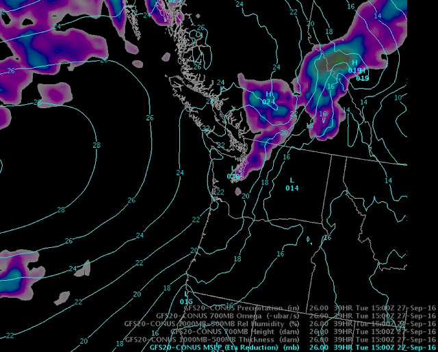
For the forecast, lingering cloud Tuesday morning with an upper level trough offshore to the north and the ridge rebuilding, sunny by the afternoon once the stratus layer rises and dissipates in a Southwest flow aloft. The ridge strengthens Wednesday into Friday with slightly warmer temperatures but sunny skies. Some inconsistencies in the models for the weekend, but as of now it looks like a large weak cool trough moves onto the coast Friday night into Saturday, bringing snow to the upper elevations. Snow line could drop to mid mountain elevations by Saturday into Sunday. More on that mid week, will post an update on Wednesday. Precipitation amounts could be minimal.
High pressure Wednesday.
Another nice day Thursday with the low getting closer.
Low should bring cloud to the area by Friday. Will update forecast for the weekend on Wed/Thurs.
That is a fairly large low.
Upper Level trough pushing through on Saturday into early next week. Cooler temps as well.
Moisture moving through the zone on Sunday into Monday.
Have lost two of my advertisers this fall so far, if anyone has any company contacts that may have an interest in placing an advertisement on the blog please e mail me at wwflann@me.com. If I cannot find enough support to generate some revenue, 5 years of hard work and archived information may come to an end. Any ideas would be appreciated!!
ARTICLES:
Skier from Golden killed in an avalanche near Lake Louise: Global News
Trevor Sexsmith--RIP: Big lines.com
Another article on the avalanche fatality: Calgary Herald
Know before you go: Whistler Traveller
Silverton Ski Patrol score early season Face Shots: Colorado
Cumulus Clouds developing over Juan de Fuca Strait last Tuesday.
Sunset Wednesday Night, Gulf Islands.
Thursday--Will Cruise Ships ever visit Squamish?--You would hope so!!!--Mostly industrial now.
Saturday morning, Ipsoot Mtn.
Saturday afternoon.
Sunday morning, overcast and drizzle. Took all day for the high pressure to have some affect.
Monday am, Warmer temperatures have melted most of the snow at 1835 meters. High of +8.
New recycling station on Nesters Road. Monday Afternoon.


No comments:
Post a Comment