3 May 2017

May 3, 2017


    AVALANCHE ACTIVITY:

    Size 3 North Face of Fitzsimmons, observed yesterday, 4+meter crown.            Dom Balik Image


    YESTERDAY:

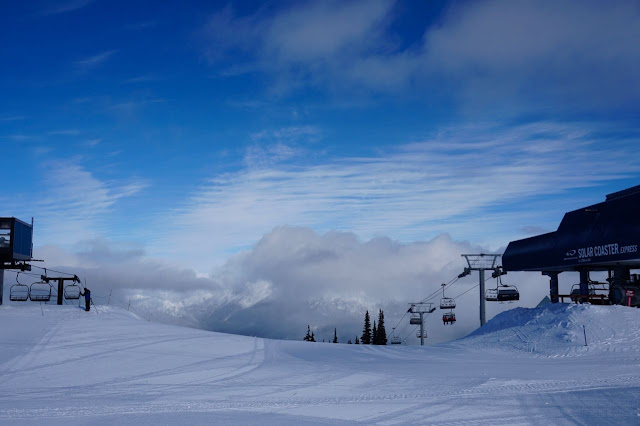
    Winter conditions, Tuesday morning May 2, 2017.

    Early Tuesday morning.

    Later Tuesday morning.

    Mid layer cloud lifted and dissipated.

    Tuesday morning.

    Preparing the bike park.

    Clouds began to roll in!!

    Late in the day Tuesday.


Weather Observations for May 3, 2017 taken at 06:00 Hours.

2240 meters      +1, Winds were 30-40 KPH S  --Horstman Hut 
1860 meters      +3, Winds were 20-30 KPH SE--Rendevous
1550 meters      +3, 4.2 mm of rain, 0 cm in 24 hrs, 247 cm Base, RH 98%  --Catskinner 
  660 meters      +6, Valley Temp, Max Temp Yesterday was +15.8, trace of Precip recorded yest

    As of 07:00 hrs we have overcast skies variable visibility and it is raining.

   FORECAST:

A warm front will bring rain to the mountains today in a Southwest flow aloft. The FL will be hovering in the 3000 meter range. Weak ridging will bring unsettled conditions for Thursday with warm temperatures and the FL exceeding 3200 meters. Friday is looking wet as another frontal band moves onshore. Saturday at this time is looking unsettled as another ridge begins to build. Sunday is looking like a warm sunny day.
Guesstimates: 5-15 mm by Thursday morning, 2-6 mm by Friday morning, 10-20 mm by Saturday morning.

   GOES IR image this am.

   Raining on the coast.

    Plume of warm moisture heading our way.

   Unsettled Thursday, showers by Thursday night.

   More precipitation for Friday.


    INFORMATION & OBSERVATIONS:


Matt Gunn
May 2 at 4:08pm
Spring skiing is finally here. Great tour in the Watersprite Lake area this morning. Fast travel allowed us to reach the lake in 2 hours from the car.

    Awesome conditions Tuesday morning.

    Sunrise in Penticton Tuesday morning.

    Warm bath.

    Awesome day in the Okanagan Tuesday.

    Still snow on the lower peaks near Penticton.


ARTICLES:

Drastic drop in the number of avalanche victims in Switzerland: SLF

Two Bear Rescues skier injured in an avalanche: Bozeman, MT

California Mammoth Snowstorms take toll on Sierra Wildlife: Fresno, CA

Avalanche danger continues in higher terrain: Colorado

North Cascades Hwy may not open until June: Wasington State

2 May 2017

May 2, 2017


    AVALANCHE ACTIVITY:

    Loose snowballing with warming temperatures reported yesterday..


    YESTERDAY:

    Monday morning May 1, 2017.

    Tuesday morning May 2, 2017.

    Some unsettled weather Monday afternoon.

    Monday morning.

    Monday evening.

   Tuesday morning.

    Big Picture Monday evening.

    Sunset in the Okanagan Monday night.


Weather Observations for May 2, 2017 taken at 06:00 Hours.

2240 meters      -6, Winds were 10-15 KPH SE--Horstman Hut 
1860 meters      -4, Winds were     0-5 KPH SE  --Rendevous
1550 meters      -3, 0 cm of new snow, 3 cm in 24 hrs, 251 cm Base, RH 94%  --Catskinner 
  660 meters     +1, Valley Temp, Max Temp Yesterday was +11.1, 0.6 mm of Precip recorded yest


    As of 06:00 Hrs this am we have clear skies, unlimited visibility and mid mtn has a stratus layer.


FORECAST:
Weak ridging will bring unsettled weather for today in a West to Northwest flow aloft. The FL will continue to rise during the day, peaking out at around 2800 meters. A warm front will move onshore later today with light/moderate precipitation into Wednesday. The FL is expected to climb above 3000 meters with warm wet conditions into Wednesday night. Thursday will see some ridging with unsettled weather in the morning with more sun as the day progresses. Friday is looking wet.
Guesstimates: 5-10 mm of rain for Wednesday morning, 5-10 mm of rain for Thursday morning, 0 mm for Friday morning, 15-20 mm for Saturday morning.


   GOES IR image from this am.

   Dry this morning

   Tuesday into Thursday.

    Moisture plume heading our way for Wednesday.

    Wet and warm on Wednesday.


    INFORMATION & OBSERVATIONS:

   Penticton sunset.

    Lake Front mural.

        Yes some nice weather would be nice!!

   Muskrat on Okanagan Lake.

ARTICLES:

Spring Report: Northwest Avalanche Center

Warm California temperatures expected to accelerate snowmelt: Associated Press

The current Western U.S. Snowpack: May 1, 2017

1 May 2017

May 1, 2017


   AVALANCHE ACTIVITY:

    Old debris in Lakeside Bowl.  Locally, no new avalanche activity to report yesterday.

    An avalanche on Mount Tsurugi in Japan has claimed a climber. Story in article section.   Net Pic


   YESTERDAY:

    Snow line below 1000 meters, Sunday April 30, 2017.

    More of the mid mountain cloud layer.

    Breaking out of the layer early Sunday morning.

    It was an awesome morning at 1860 meters.

    Sunday morning.

    Clouds thickened up as the day progressed.

    Horstman T Bar in the afternoon.


    Big picture Sunday afternoon.

    Later in the day.

    Some breaks at sweep.

    Sunday evening.

    Large cumulus clouds just before dusk.

Weather Observations for May 1, 2017 taken at 06:00 Hours.

2240 meters      -6, Winds were 10-15 KPH SE--Horstman Hut 
1860 meters      -4, Winds were   5-10 KPH SE--Rendevous
1550 meters      -2, trace of new snow, 1 cm in 24 hrs, 251 cm Base, RH 92%  --Catskinner 
  660 meters     +1, Valley Temp, Max Temp Yesterday was +10.1, trace of Precip recorded yest


    As of 07:00 hrs this am we have overcast skies and variable visibility.

FORECAST:

A weak upper level trough in a Northwest flow aloft will bring showery weather to the area today with the FL rising to 1600 meters. A weak upper level ridge will begin to build tonight for unsettled weather on Tuesday. By Tuesday night another warm front will bring precipitation to the area into Wednesday night with the FL rising above 3000 meters. Another weak ridge is expected for Thursday with mostly sunny skies and warm temperatures. Friday is still up in the air, it may be very wet. More on  that as we get closer.
Guesstimates: trace to 2 cm by Tuesday morning above 1500 meters, 8-10 mm of rain by Wednesday morning, 10-15 mm of rain by Thursday morning, trace - 2 mm of rain by Friday morning.

    GOES IR Image from this am.

    Hopefully the moisture will go North.

   Mostly overcast for today.

   We may see some breaks.

    Unsettled Tuesday.

   Tuesday into Thursday.

   Looks like some precip on Wednesday.

    Drys out again on Thursday.


INFORMATION & OBSERVATIONS:


    Australian Mogul Team has their work cut out for them.

   Moisture leaving the snow pack.

   New addition to the Avalanche Dog Program.

   Graupel in the cord.

   Still looks like winter on Whistler.

ARTICLES:

An avalanche has killed a climber on Mount Tsurugi: Japan

Backcountry like a boss with Spring Safety Tips: Bay of Islands SAR

Crippling Destructive winter storm: Ursa