27 Jan 2018

January 27, 2018


    AVALANCHE ACTIVITY:

    An avalanche in Abondance, France has killed a skier. Story in article section.                    Net Pic

    Na soft slab avalanches during the day.

    Surface releases. Up to Sz 3 natural avalanches in the corridor.

    Sz 3 Xh yesterday morning in the Poop Chutes off Phalnax Ridge.

    Debris off Phalnax ridge well into the flats.

    Whiplash filling in after Monday's event. Avalanche control yesterday produced Sz 1.5-3 Xe Xh Sc


    YESTERDAY:

    Friday morning in the valley, more snow in Rainbow than on the hill.

    Convective flurries during the morning.

   Snowing to the valley.

    Overcast in the morning.

    Blue in the afternoon.

    Spindrift above Ruby Bowl.

    Skiing sucked Friday!!!                                                                                                    JB Image

    Convective clouds went through Friday morning.

    Just before Dusk.

    Snow in the trees is still accumulating.

     Super Blue Moon on January 31, 2018.

    Friday afternoon, breaks on the way.

    Big picture Friday afternoon.


Weather Observations for January 27, 2018  taken at 06:00 Hours.

2180 meters     -8, Winds were 50-65 KPH ESE--Whistler Peak
1835 meters     -9, Winds were   5-10 KPH S     --Roundhouse
1660 meters     -8, 11 cm of new, 24 cm in 24 hrs  Base 302 cm --Pig Alley
  660 meters     -2, Valley Temp, Max Temp Yesterday was +0.5, 3.8 mm of precip recorded yest


    As of 07:00 Hrs this am we have overcast skies, limited visibility and it is snowing lightly.


FORECAST:

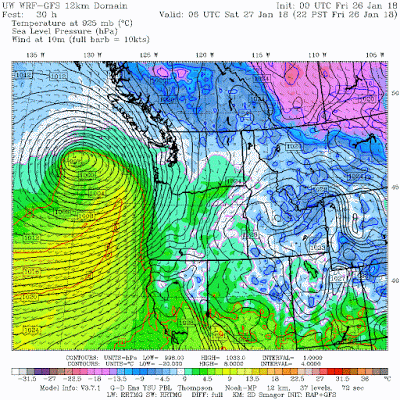
A modest low pressure system is pushing onto the coast today in a Southerly flow aloft. The freezing level is expected to rise to around 1000 meters with moderate winds and light/moderate snowfall.
A strong warm front and associated atmospheric river arrives on Sunday, stalling and exiting by Monday afternoon as a welcome cold front pushes through. Freezing level on Sunday will gradually climb to 1800 meters before descending to about 800 meters by Monday night. Cool and showery weather is forecasted for Tuesday into Wednesday. A ridge will begin to build on Wednesday night with unsettled conditions expected for Thursday.
Guesstimates: 15-20 cm by Sunday morning, 20-35 cm by Monday morning above 1700 meters, 25-35 cm by Tuesday morning, 10-15 cm by Wednesday morning.


    GOES IR image this am.

     Freezing level below surface this am.

    Started snowing again early this am.

    Modest low with moderate winds and moderate/heavy precipitation.


    Warming up by this afternoon, 1000 m FL.


    Fronts on the coast today.


    Warm front on Sunday associated with an atmospheric river.


    INFORMATION & OBSERVATIONS:

    Point releases in the am.

    Great snow!!!

    Loose new snow point releases in the afternoon as well..


    Ruby Bowl was awesome.

    From 06:00 to 14:00 Hrs we had 12 cm of new, base 228 cm at 1550 m. At Pig alley 13 cm of new.


    Size 1 Sc during the day.

    Blackcomb Glacier Creek.

    Spanky's ladder was very busy. Conditions are as good as they get.

    Just before dusk.

From South Coast Touring:

Scott Mackenzie
January 26 at 9:50pm
Some wind slab action today up Brohm ~1600m. Set Several small ones on N and W faces. Shooting cracks while skiing some spots.


Mitchell Sulkers posted 2 photos.
17 hrsInstagram

Another good dump overnight and this morning with 35cm new on Sproatt. With some clearing it was evident that almost all sudden convexities had run on E through NW asp during last night's storm at TL. Some crowns and flanks to 70cm est in non-rideable terrain.
Trailbreaking to ALP went from 20cm near valley to 35 at TL. At treeline and above deep soft alabs made for more difficult trailbreaking. Some whumpfing and cracking began immediately at TL.
Sluffs running on anything 35 deg or steeper. Ski pen ridiculous with cold dry smoke. Still some open creeks so not all gullies completely good to go, but awesome touring from the back door!


Recent MIN Reports from Avalanche Canada:

Cowboy Ridge

Sproatt Northwest


ARTICLES:

An avalanche has killed a skier in France: Haute-Savoie

Mount Hood Ski Patroller hurt in avalanche: Oregon

Three skiers caught in an avalanche in Big Cottonwood Canyon: Utah

Flooding & Avalanche Risk to increase this weekend: B.C. Storm

Avalanche Survivor shares his story: 'It was like drowning'

A new battery-powered avalanche airbag: Scott

Avalanche risk expected to rise this weekend: News 1130

26 Jan 2018

January 26, 2018


    AVALANCHE ACTIVITY:

    An ice climber is presumed dead after an avalanche in the Dolomites, Italy. Story below. Net Pic

    Avalanche control produced a size 3 in West Bowl,  Monday's is closed . 2.5 meter drop at the top.

    Late November crust or Early December crust??

    There is debris in West Bowl down to the road. Avalanche control produced Sz 1-3.5 Thursday.

    Yesterday, evidence of natural avalanches up to Sz 3 were observed in the Sea to Sky Corridor.


    YESTERDAY:

    Some very light flurries on Thursday morning.

    Unsettled in the morning.

    More cloud as the day progressed.

    There were some good turns to be had!!

    First at the top.

   Awesome light early in the day.

    Overcast in the afternoon with some light snow.

    Snowing harder just after dusk, sunset was at 16:53 on Thursday.


Weather Observations for January 26, 2018  taken at 06:00 Hours.

2180 meters     -9, Winds were 30-45 KPH SE --Whistler Peak
1835 meters     -9, Winds were 15-40 KPH SE--Roundhouse
1660 meters     -7, 15 cm of new, 18 cm in 24 hrs  Base 295 cm --Pig Alley
  660 meters     -2, Valley Temp, Max Temp Yesterday was +2.6, 3.4 mm of precip recorded yest

    As of 07:00 Hrs this am we have overcast skies, limited visibility and it is snowing lightly.


FORECAST:

A cool and unstable airmass will bring mostly overcast skies and periods of light snowfall in a Westerly flow aloft. Looks like some breaks this am.  The freezing level will remain below surface. A low will push onto the coast for Saturday with light snowfall and a rising freezing level. Saturday, the FL should max out at 1000 meters dropping back to the surface Saturday night. A strong warm front will be here by Sunday, stalling over the area, exiting on Monday.  This is considered an atmospheric river event with the FL rising to 1800 meters by Sunday night. The freezing level will slowly drop back down to 900 meters by Monday evening. A northwest flow aloft on Tuesday with a building ridge will bring unsettled weather for most of next week.
Guesstimates: 10-20 cm by Saturday morning, 10-20 cm by Sunday morning, 20-40 cm by Monday morning above 1700 meters, 30-45 cm by Tuesday morning.

    GOES IR image from this am.


      Cooler unsettled day.


    Flurries for today.


    Fronts on the coast.


    Change on Saturday, its going to warm up!


    Atmospheric river for Sunday.


    INFORMATION & OBSERVATIONS:

    Sluffing in the morning on steep slopes.

    Some wind effect but mostly nice turns to be had!!

    New snow--soft slabs!!

   Tres fragile!!

    Natures sculpting.

    How much snow can the trees hold?

    Great conditions all day long!!!

    Rough day at the office!!

    Interesting shot from Doug Tuck.

                    Light snow yesterday.                                                               JB Image


Recent Avalanche Canada MIN Report:

Oboe


VIDEO FRIDAY:

Avalanches in Zermatt: Switzerland

Touchy Conditions: Colorado

Avalanche Footage: Europe

Locals interviewed about avalanches: Shaw TV

Boarder has to dig his friend out: Ponoka News


ARTICLES:

Ice climber presumed dead after an avalanche in the Dolomites: Italy

Weekend storm forecast promts avalanche warning from Avalanche Canada: CBC News

Cloud seeding for snow!-Does it work: Science Daily

Skier caught in avalanche on Pointy Peak in Park City: Utah

Can computers forecast avalanches better than humans digging holes: ScienceLine

Search for missing snowboarder suspended: Mount Baker