18 Mar 2023

March 18, 2023

      AVALANCHE ACTIVITY:

       An avalanche has killed a skier in Austria. Article below. Serfus-Komperdell Ski Area. Net Pic

      Skier entered at top right, buried where circle is. No Transceiver. Samanaun Massif. 

      Where the skier had entered.                                                                               Alpinpolizei Pic


      No new avalanches observed on Whistler Friday. Some wet loose on steep solar terrain.


     Xc from 2023/03/16. Large Cornice Debris.


      Some big chunks.


      No new avalanches observed on Blackcomb. Some wet loose lower elevations.

      Xc on Blackcomb Friday. Xc Sz 1.5 cornice debris Bushwhip.


     Wet loose from 2023/03/16 later in the pm. Sz 1 Na. Lakeside Bowl.


       Na Sz 1.5 likely small cornice tab to slab, ? Thursday night,  into lower Body Bag Bowl.


       Fracture Line From 2023/03/16 S-Turn Sa Sz 1.5.                                                                 JA Image


          S-Turn avalanche debris.                                                                                          JA Image


       Snow bomb off rocks dry loose from 2023/03/16.


      Wet loose from 2023/03/16.

      New avalanche deflector berm above Peak Chair Load.


      WEATHER YESTERDAY:

      Sunrise Friday was at 07:22 Hrs. -7 Deg C with a 10-15 KPH ESE wind at 1860 m.


      08:00 Hrs. -7 Deg C with a 5-10 KPH ESE breeze at 1860 m.

     10:00 Hrs. -6 Deg C with a 25-30 KPH South wind at 2280 m. Cloud pushing in!


      Friday March 17, 2023. 12:00 Hrs. -2 Deg C with a 5-15 KPH ESE wind at 1835 m.

      14:00 Hrs. -5 Deg C with a 20-30 KPH SSW wind at 2280 m.

      18:00 Hrs. -5 deg C with a 15-20 KPH Se wind at 2280 m.


Weather Observations for March 18, 2023 taken at 06:00 Hours.

2280 meters     -6, Winds were 20-25 KPH S--Horstman Hut
2180 meters     -5, Winds were 40-45 KPH S--Whistler Peak
1860 meters     -3, Winds were 10-20 KPH ESE --Rendezvous  
1835 meters     -2, Winds were 10-15 KPH ESE--Round House
1650 meters     -3, 0 cm in 12 Hrs, 0 cm in 24 Hrs. Base 235 cm--Pig Alley
1570 meters     -2, 0 cm in 12 Hrs, 0 cm in 24 Hrs. Base 159 cm--Catskinner
  660 meters     -2, Valley Temp, Max temp Yesterday was +9.2, 0.0 mm of precip yesterday


      As of 06:00 Hrs we have no new snow. Base 235 cm.


       As of 07:00 Hrs we have broken cloud and unlimited visibility.


FORECAST:

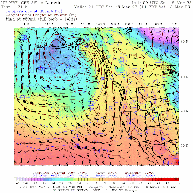
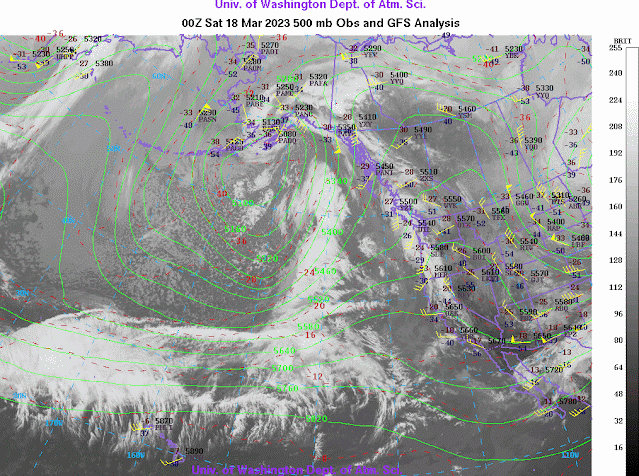
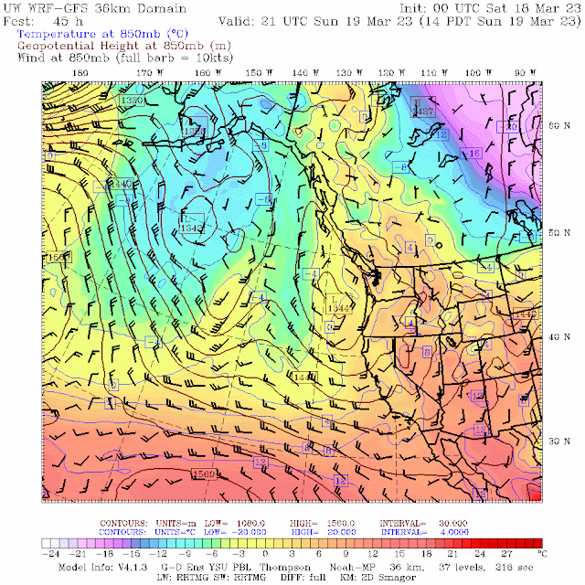
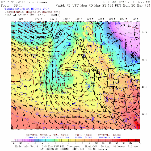
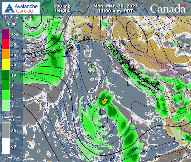
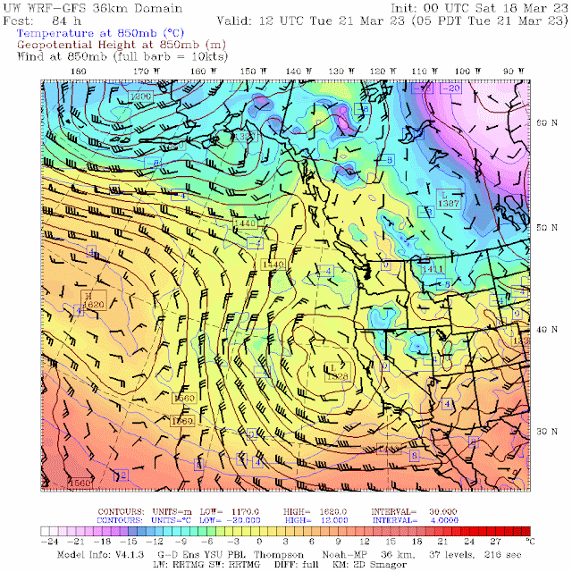
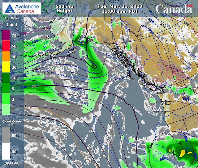
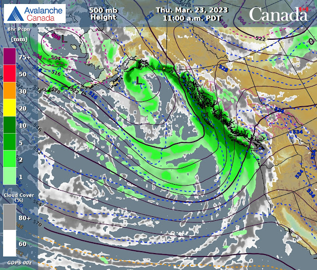
Weak ridging for today with mostly sunny skies this am with increasing cloud cover in the pm in a Southerly flow aloft. The FL is just below surface, rising to 1800+?m by this afternoon, dropping back to just below surface tonight. Low along the coast will spill cloud into the area Sunday with overcast skies. Stays dry. Weak front arrives Monday afternoon with periods of light precipitation into Tuesday. Seasonable temperatures. Weak ridging for Wednesday with a mix of sun and cloud with some flurries possible in the mix. Another frontal band for Thursday with light precipitation. Mostly overcast with some flurries Friday. Cooler temperatures. Guesstimates: 0 cm by Sunday am, 0 cm by Monday am, 4-8 cm by Tuesday am, trace-2 cm by Wednesday am, o-trace by Thursday am, 8-12 cm by Friday am.


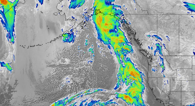
      GOES IR IMAGE from this am.


       Ridge holding with cloud spilling in for mix of sun and cloud Saturday. Warm daytime temps.


      WINDY IMAGE 2023/03/18. 05:00 Hrs.


      Southerly flow aloft.


       Low moves down the coast, overcast skies for Sunday. Warm daytime temps in the valley.


      Moisture moves down the coast well off shore. Dry day for Sunday.

              Trough moves on shore with convective activity Monday. Slightly cooler.


      Periods of light precipitation for Monday.


        Low well to the South on Tuesday, lingering precipitation Tuesday am, dries out in pm.


      Light precipitation Tuesday am, dries out in the pm.


      Dirty ridging for Wednesday with mixed bag with chance of some flurries in the alpine.


      Another frontal band on Thursday, light precipitation.


      INFORMATION & OBSERVATIONS:

       Busy at 09:30 Hrs.


       It was a Happy St Paddy's Day.


      New avalanche deflector berm above base load Peak Chair.


       Interesting morning light.


      Many souls venturing to the top of Flute.


      Still some nice dry powder to be had.


      Pipe Line and Pakalolo.


      Many layers since the first snows. 725 cm recorded this season at 1650 m.

      The Dominator could use some more snow!!


      Cool filtered light in the late pm. High overcast thickened later in the day.


      18:00 Hrs, clouds were still moving in from the South.

       Recent profile.


FROM AVALANCHE CANADA:

Travel and Terrain Advice:

Be careful with wind slabs, especially in steep, unsupported and/or convex terrain features.

Closely monitor how the new snow is bonding to the crust.

Avoid sun exposed slopes when the solar radiation is strong, especially if snow is moist or wet

Pay attention to cornices and give them a wide berth when traveling on or below ridges.


MODERATE--Sea to Sky advisory available top right sidebar!


LOCAL MIN REPORTS:

No new reports as of 07:00 Hrs.


SHORT CLIPS:

North Shore Avalanche Conditions: March 17, 2023

Recent Skier Triggered Avalanche: Colorado

Different footage from the avalanche in: Tignes

Bigger Paddles would help: ? Life jacket

Treed: Bummer

Nice turns until the avalanche caught up: Snowboarding


ARTICLES:

A 20 year-old female has died in an avalanche: Austria

Avalanche conditions report 2023/03/18; Austria

No one caught in slush avalanche in Kvinnherad; Norway

Skier triggered avalanche with burial, Mount Washington: New Hampshire

Report reveals new details of Spring Mountain avalanche fatality: Nevada

NAC's New Platform improves US Avalanche Forecasts: Powder Cloud

Zenith Guides Snow Report: March 16, 2023


      If you enjoy the content and find it useful, please hit the donate button, top right on side bar.


Send me recent avalanche images. E-Mail top right of the side bar. Read Below:


Goggle contest returning again this year, win a pair of Marker goggles for the best avalanche image for the months of February-March, April-May.  Grand prize best image of the  season will be a Pair of Prior Skis or a Split Board awarded at the end of May. 

17 Mar 2023

March 17, 2023

     AVALANCHE ACTIVITY:

       Another fatal avalanche in Verbier Ski Area, Switzerland. Article below.                    Valais Police Pic


          Sz 1.5 Sa 2023/03/16 Poop Chutes                                                                                   NK Image

      A bit closer.                                                                                                                     AC Pic


      Sz 1.5 Sa in S Turn.                                                                                                                  NK Pic


       Looking down the slide path.                                                                                                NK Image


      Those trees have been hit before!!                                                                                      NK Image


      Some cornice control performed Thursday on Whisler.


      Cornice control with explosives Xc in Flute Thursday am. Sz 2 cornice debris.


      Older cornice debris in Glacier Bowl.


      Some cornice control on Blackcomb Thursday. Sz 1.5 X 2 in Blackcomb Provincial Park.


      Sz 1 Xc Fallers East Thursday am.


       Snow balling and pinwheeling Thursday afternoon.


      Small Pinwheel.


      WEATHER YESTERDAY:

      Sunrise on Thursday was at 07:24 Hrs. -7 Deg C with a 5-10 KPH ESE wind at 1835 m.

      08:00 Hrs. -7 Deg C with a 0-5 KPH Variable breeze at 1860 m.


      10:00Hrs. -6 Deg C with a 5-10 KPH ENE wind at 1835 m.


     Thursday March 16, 2023. 12:00 hrs. -5 Deg C with a 5-10 KPH NE breeze at 1835 m. 


      14:00 Hrs. 0 Deg C with a 5-10 KPH SW wind at 1860 m.


      16:00 Hrs. -5 Deg C with a 15-20 KPH South wind at 2280 m.


Weather Observations for March 17, 2023 taken at 06:00 Hours.

2280 meters     -9, Winds were 20-25 KPH S--Horstman Hut
2180 meters     -8, Winds were 25-30 KPH SE--Whistler Peak
1860 meters     -7, Winds were   5-10 KPH SE --Rendezvous  
1835 meters     -6, Winds were 10-15 KPH SE--Round House
1650 meters     -7, 0 cm in 12 Hrs, 0 cm in 24 Hrs. Base 240 cm--Pig Alley
1570 meters     -6, 0 cm in 12 Hrs, 0 cm in 24 Hrs. Base 162 cm--Catskinner
  660 meters     -5, Valley Temp, Max temp Yesterday was +7.6, 0.0 mm of precip yesterday.


      No new snow on the board. Base ? 240 cm.


      As of 07:00 Hrs this am we have clear skies and unlimited visibility.


FORECAST:

Ridge in place this am with sunny skies, should see some high cloud development as the day progresses in a Southerly flow aloft. The FL is presently below surface with daytime heating bringing the FL to around 1800 m this pm dropping back to around surface tonight. Dirty ridging for Saturday with a mix of sun and cloud. Very weak shortwave trough in the mix. Weather from the North will send cloud our way on Sunday with mostly overcast skies. Some flurries Sunday night as the frontal band moves into the area for Monday with light/moderate precipitation. Front dissipates early Tuesday am with mostly overcast skies for the remainder of the day. Weak ridging for Wednesday am with a mix of sun and cloud, some flurries possible. A frontal band is forecasted for Thursday. Time will tell. Guesstimates: 0 cm by Saturday am, 0 cm by Sunday am, 1-3 cm by Monday am, 8-12 cm by Tuesday am, 0-trace by Wednesday am, 0-trace by Thursday am, 5-10 cm by Friday am. 


      GOES IR image from this am.


       WINDY IMAGE 2023/03/17. 05:00 Hrs.


       High strengthens this am with warm temperatures for St Paddy's Day. Overcast in the pm.


      Dry for Friday with warm daytime highs.


      Southerly flow aloft.


                Dirty ridging for Saturday with a mix of sun and cloud. Warm pm temps.


      Low moves down the coast, dry day with no precipitation Saturday.


        Low to the North will send a frontal band down the coast Sunday night. Warm.


      Dry Sunday am/pm with frontal band arriving Sunday night. 


        Low off the coast, frontal band for Monday with precipitation. Cooler temps.


      Light/moderate precipitation on Monday. 


      Frontal band dissipates early Tuesday am, lingering cloud with dry weather.


      Dirty ridging on Wednesday, dry with a mix of sun and cloud.


     INFORMATION & OBSERVATIONS:

     09:13 Hrs.


      Great looking snow in the alpine.


      Surface Hoar had a good night.


      Sweet looking turns.


      Cowboy Ridge.


      Not the same as being on Cowboy Ridge.


      Just a bit of exposure!


      Moist snow in the valley Thursday pm. High in the valley of +7.6 deg C.


      Awesome early morning Friday. 04:00 Hrs. -9 Deg C with a 20-25 KPH South wind at 2280 m.


FROM AVALANCHE CANADA:

Travel and Terrain Advice

Watch for newly formed and reactive wind slabs as you transition into wind affected terrain.

Closely monitor how the new snow is bonding to the crust.

Avoid sun exposed slopes when the solar radiation is strong, especially if snow is moist or wet

Pay attention to cornices and give them a wide berth when traveling on or below ridges.


CONSIDERABLE!!--SEA TO SKY ADVISORY available top right sidebar!


LOCAL MIN REPORTS:

Foon Alley & Poop Chutes: March 16, 2023


SHORT CLIPS:

Bucked Off: Bronco Sled

Avalanche started from cornice chunk: Colorado

Sz 1 Sa Soft Slab: Avalanche

High marking: Alaska


ARTICLES:

Another fatal avalanche in Verbier: Switzerland

9-year-old boy found in 'semi-conscious' condition after being buried in roof avalanche: Utah

Near miss as Massive avalanche sweeps through French Ski Resort: Tignes

Skiers race to escape avalanche at Tignes in harrowing video: France

Massive avalanche hits ski resort in Sochi: Russia

Snowboarder killed in Pauline Peak Avalanche identified: Oregon

On the mountain, risk can be mitigated, never eliminated: Globe & Mail

Berthoud Pass back open after avalanche closure: Colorado


      If you enjoy the content and find it useful, please hit the donate button, top right on side bar.


Send me recent avalanche images. E-Mail top right of the side bar. Read Below:


Goggle contest returning again this year, win a pair of Marker goggles for the best avalanche image for the months of February-March, April-May.  Grand prize best image of the  season will be a Pair of Prior Skis or a Split Board awarded at the end of May.