AVALANCHE ACTIVITY:
Appa Glacier area, more recent cornice collapse. AC Pic
Sz 2 Cornice debris, no slab pulled out. ?72 Hrs old. Up in the Ryan Area. AC Pic
No new avalanches observed on Blackcomb. Alpine closed due to lack of snow.
WEATHER YESTERDAY:
Sunrise Friday was at 05:20 Hrs. +7 Deg C with a 5-10 KPH SE breeze at 1860 m.
08:00 Hrs. +9 Deg C with a 5-10 KPH ESE breeze at 1860 m.
10:00 Hrs. +11 Deg C with a 0-5 KPH East wind at 1860 m.
Friday May 19, 2023. 12:00 Hrs. +13 Deg C with a 2-6 KPH SW breeze at 1835 m.
14:00 Hrs. +14 Deg C with a 5-15 KPH West wind at 1860 m.
16:00 Hrs. +13 Deg C with a 5-15 KPH NE wind at 2280 m.
21:30 Hrs. +9 Deg C with a 0-5 KPH NNE puff at 2280 m.
Weather Observations for May 20, 2023 taken at 06:00 Hours.
2280 meters +8, Winds were 25-30 KPH S--Horstman Hut
1860 meters +8, Winds were 10-15 KPH SE--Rendezvous
1650 meters +8, 0.1 mm in 12 Hrs, 0.1 mm in 24 Hrs. Base 137 cm--Pig Alley
1570 meters +9, 0.0 mm in 12 Hrs, 0.0 mm in 24 Hrs. Base 39 cm--Catskinner
660 meters +9, Valley Temp, Max temp Yesterday was +27.9, 0.2 mm of precip yesterday.
High Friday at 2280 m was +14.9 Deg C at 18:15 Hrs.
High Friday at 1860 m was +17.3 Deg C at 18:15 Hrs.
As of 06:00 Hrs 0.0 mm of precipitation. Base 137 cm at 1650 m.
As of 07:00 Hrs we have broken cloud and unlimited visibility.
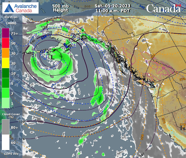
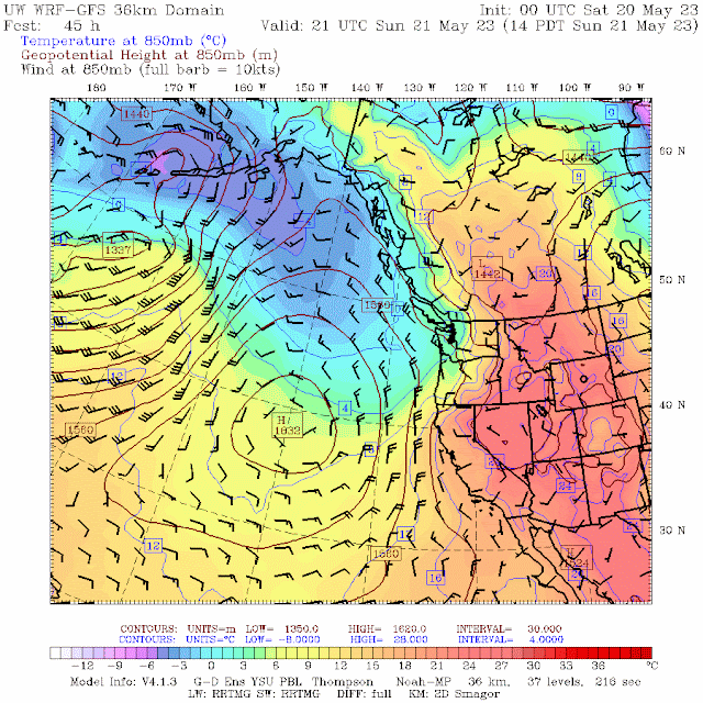
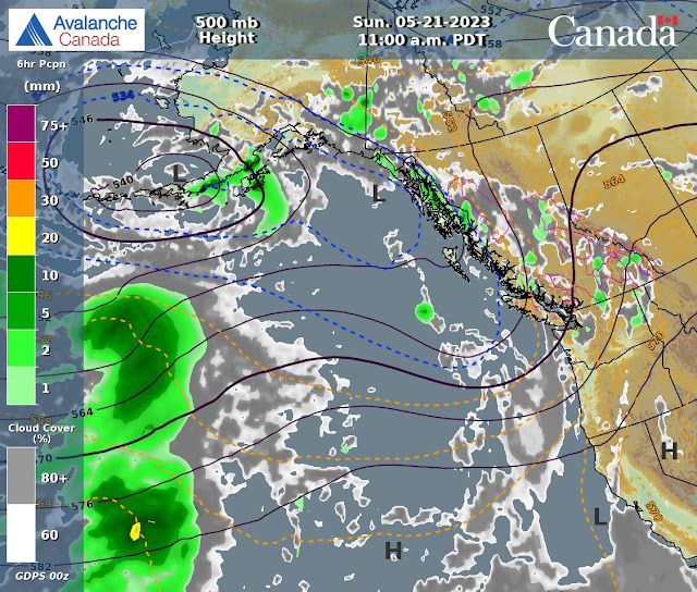
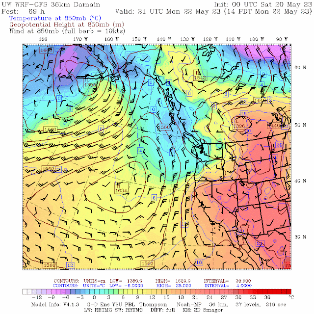
FORECAST:
Dirty ridging will bring a mix of sun and cloud for today in a Southwesterly flow aloft. The FL is hovering around 3500 m and will likely go back up to 3800 m with daytime heating. Dirty ridging for Sunday with the chance of an afternoon isolated shower in the mix. Low will begin to cool down the airmass by Sunday night into Monday am with seasonable temperatures. Periods of light precipitation on Monday with a mix of sun and cloud. Unsettled Tuesday am with increasing cloud cover and periods of light precipitation. Mix of sun and cloud for Wednesday into Thursday with seasonable temperatures. Guesstimates; 0 mm by Sunday am, 0-trace by Monday am, 2-6 mm by Tuesday am, 1-4 mm by Wednesday am, trace-2 mm by Thursday am.
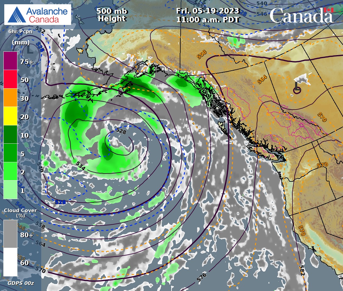
GOES IR IMAGE from this am.
.jpeg)
WINDY IMAGE 2023/05/20. 05:00 Hrs.
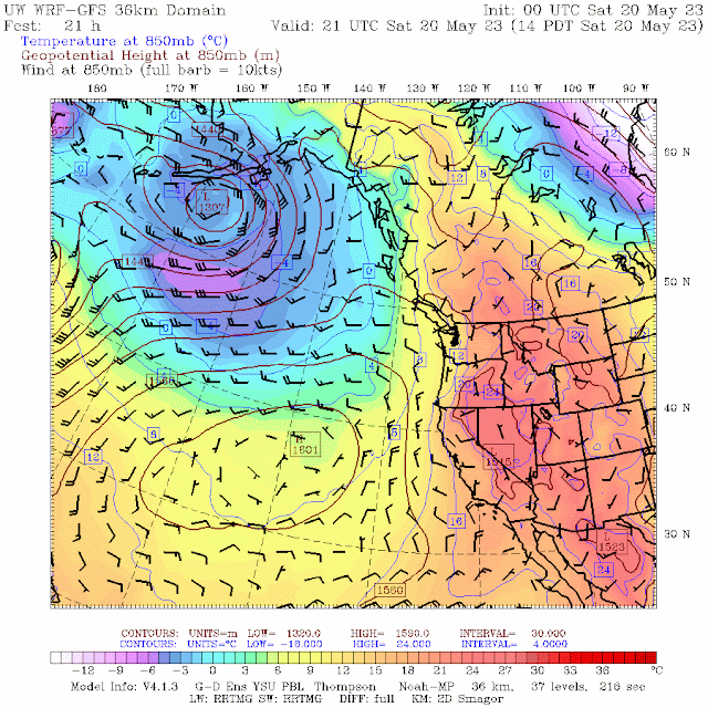
Dirty ridging for Saturday with a mix of sun and cloud. Above average temperatures.
No precipitation for Saturday.

Southwesterly flow aloft.
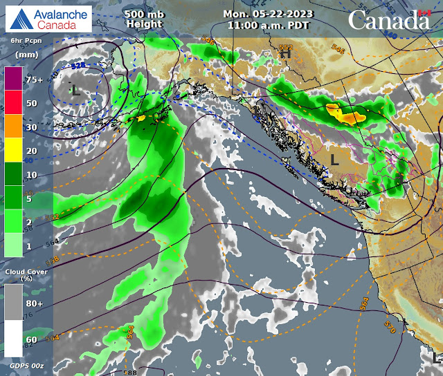
Dirty ridging for Sunday with a mix of sun and cloud.m Possible showers in the PM.
Chance of some convective showers in the afternoon on Sunday.
Weak upper level trough, dirty ridging brings an unsettled day with clouds, sun, showers.
Low brings an unsettled day Monday with mix of sun, cloud, and periods of light rain. Seasonable temps.

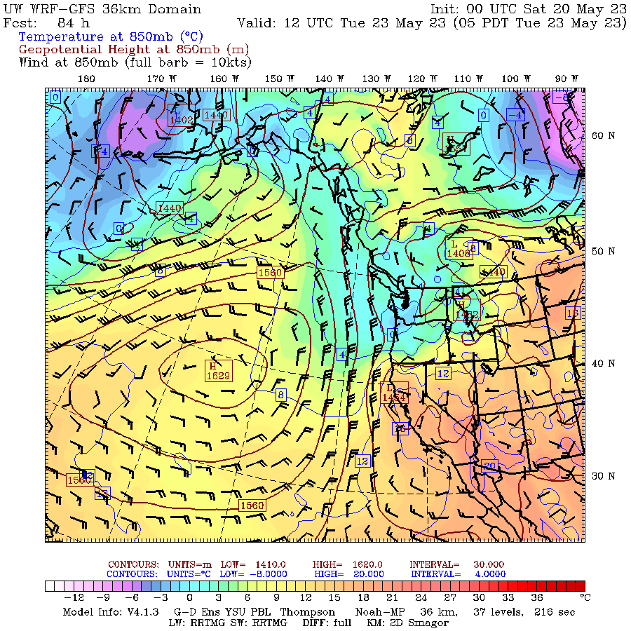
Upper trough will bring cooler temps, periods of light precipitation on Tuesday.
Low will bring some rain with sun and cloud in the am on Tuesday, overcast and rain in the pm.
Dirty ridging for Wednesday, mix of sun and cloud.
Dirty ridging Thursday with a mix of sun and cloud. Seasonable temperatures.
INFORMATION AND OBSERVATIONS:
Mix of sun and cloud Friday am.
09:20 Hrs upload Friday. More bikers than skier/snowboarders.
Cumulus cloud development in the am.
Horstman Creek coming down by the Bite.
There is a lot of melt coming off the Horstman Glacier.
Cumulus clouds kept building as the day progressed.
Watering the grass under the Accelerator Chair.
Fast snow in the am.
Grass is growing in the valley, fertilizer helps!!
Park City Chairlift in Whistler. Zoom in left side of the enormous chair.
Not much snow on Wedge for this time of the year!!
Might feel that way this weekend.
There has been a lot of melting going on!!!
Green Lake is full!!!
Big Log in Fitzsimmons Creek.
Season quickly coming to an end.
Lost lake at sunset, which was at 20:57 Hrs.
FROM AVALANCHE CANADA:
Backcountry Avalanche Advisory – Sea to Sky
Avalanche Canada advisories are done for the season. Advisories are typically available in fall, winter and spring (October – April). Please check back in Fall 2023 for Whistler and the Sea to Sky region advisories. If you're heading into the mountains this spring, learn more about assessing spring conditions.
LOCAL MIN REPORTS:
No new MIN reports as of 07:00 Hrs.
SHORT CLIPS:
Jump Fail: Ouch
Flying Low: Wow
Sending it down the: Stairs
Look Ma: No hands
ARTICLES:
All Melt, No Freeze: Avalanche Canada
Complications arise in the West as early heat wave causes snowpack to melt rapidly: ABC News
11 more temperature records broken, one tied in B.C, as sizzling days fizzle out: Global News
Hurley Road: Open
If you enjoy the content and find it useful, please hit the donate button, top right on side bar.
Send me recent avalanche images. E-Mail top right of the side bar. Read Below:
Goggle contest returning again this year, win a pair of Marker goggles for the best avalanche image for the months of April-May. Grand prize best image of the season will be a Pair of Prior Skis or a Split Board awarded at the end of May.

.jpeg)
.jpeg)
.jpeg)
.jpeg)
.jpeg)
.jpeg)
.jpeg)
.jpeg)
.jpeg)
.jpeg)
.jpeg)
.jpeg)

.jpeg)


.jpeg)
.jpeg)
.jpeg)
.jpeg)
.jpeg)
.jpeg)
.jpeg)
.jpeg)
.jpeg)
.jpeg)
.jpeg)
.jpeg)
.jpeg)
.jpeg)
.jpeg)
.jpeg)
.jpeg)
.jpeg)

.jpeg)
.jpeg)
.jpeg)
.jpeg)
.jpeg)
.jpeg)
.jpeg)
.jpeg)
.jpeg)
.jpeg)
.jpeg)
.jpeg)
.jpeg)

.jpeg)


.jpeg)
.jpeg)
.jpeg)
.jpeg)
.jpeg)
.jpeg)
.jpeg)
.jpeg)
.jpeg)
.jpeg)
.jpeg)
.jpeg)
.jpeg)
.jpeg)