23 Jan 2023

January 23, 2023

      AVALANCHE ACTIVITY: 

       Numerous large avalanches near Valemount, B.C. Article Below.                Allen Creek Image

     A snowmobiler has died in an avalanche near Valemount, B.C. Article below. Robson Fletcher Pic


   Avalanche control on Whistler produced some Sz 1 cornice and storm slab results Xc Xe on Sunday.


      Xe Sz 1 above Glacier Bowl Whistler Peak.


     No new avalanches observed on Blackcomb. Xc (cornice control) in Blackcomb bowl.


      Old wet loose up Fitzsimmons Valley.


      Sz 3 Na San Juan Area, CO. 2023/01/22. Click> CAIC Report.                        Chris valine Pic


      WEATHER YESTERDAY:

      Sunrise Sunday was at 07:59 Hrs. -7 Deg C with a 0-5 KPH variable directions at 1860 m.

     10:00 Hrs

      Sunday January 22, 2023. 12:00 Hrs. -6 Deg C with a 5-10 KPH SSW breeze at 1835 m.


      14:00 Hrs. -8 Deg C with a 10-15 KPH South wind at 2280 m.


     16:00 Hrs.-6 Deg C with a 5-10 KPH South wind at 1860 m.


Weather Observations for January 23, 2023 taken at 06:00 Hours.

2280 meters     -8, Winds were 20-45 KPH SW--Horstman Hut
2180 meters     -8, Winds were 25-35 KPH SW--Whistler Peak
1860 meters     -5, Winds were   5-10 KPH S--Rendezvous  
1835 meters     -6, Winds were 10-20 KPH SSW--Round House
1650 meters     -6, trace in 12 Hrs, 1 cm in 24 Hrs. Base 195 cm--Pig Alley
1570 meters     -6, trace in 12 Hrs, 1 cm in 24 Hrs. Base 132 cm--Catskinner
  660 meters     -1, Valley Temp, Max temp Yesterday was +2.1, 0.0 mm of precip yesterday. 


      As of 06:00 Hrs this an we have a trace of new snow. 0.5 mm in the precip gauge. 195 cm Base


      As of 07:00 Hrs this am we have broken cloud and unlimited visibility.


FORECAST:

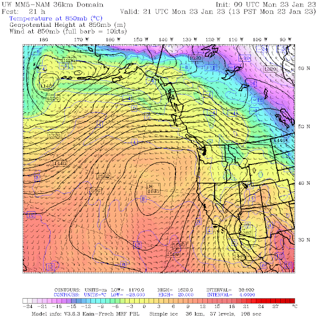
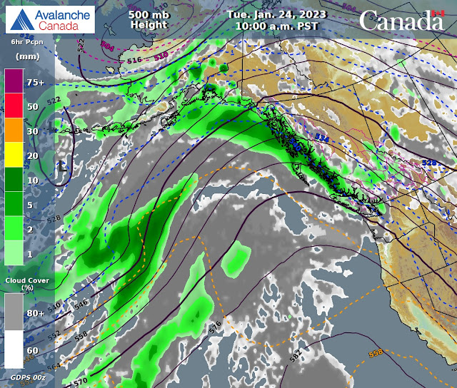
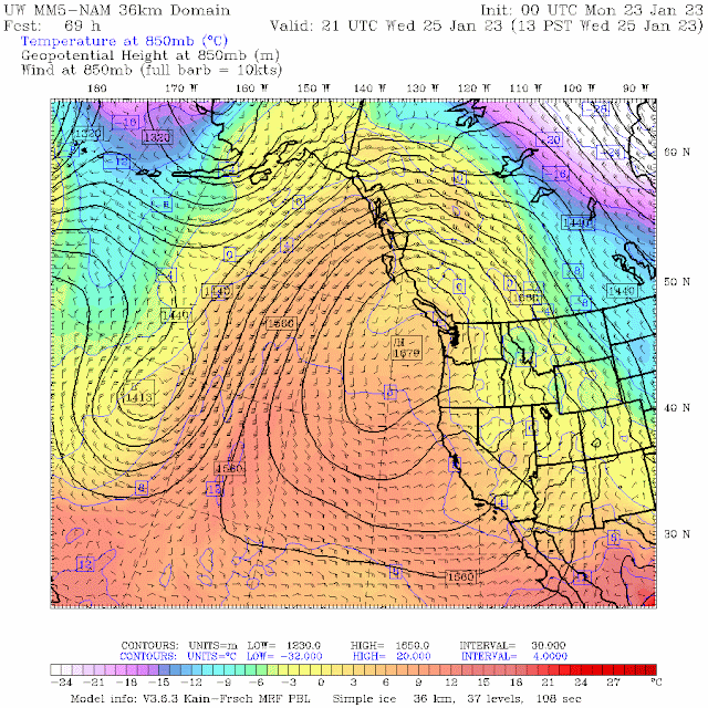
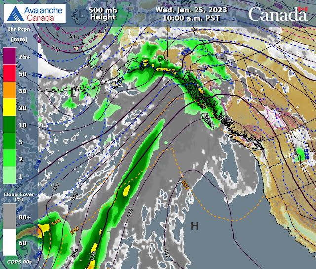
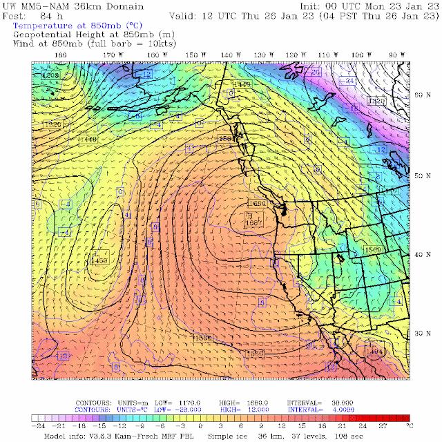
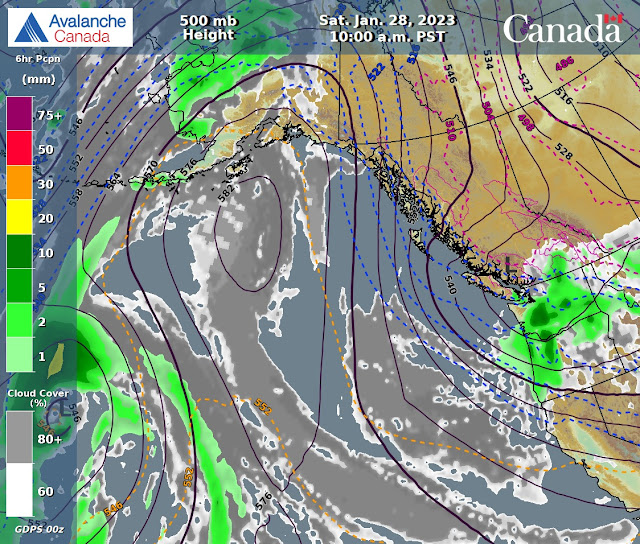
A dirty ridge is off the coast, low from the North will spill cloud into the area in a Northerly flow aloft. Unsettled weather for Monday with a dry airmass. Mix of sun and cloud but mostly overcast. Ridge continues too push onshore Tuesday with overcast skies and dry weather. Ridge strengthens for Wednesday with a mix of sun and cloud. Mostly sunny in the pm. Unsettled Thursday am with a short wave trough pushing in Thursday pm into early Friday am. Dries out in the early am, with unsettled weather for the remainder of the day. Ridge builds again on Saturday with a mix of sun and cloud and cooler arctic air pushes to chill the weather pattern. Guesstimates: 0-trace by Tuesday am, 0-trace by Wednesday am, 0 cm by Thursday am, trace-2 cm by Friday am, 2-6 cm by Saturday am.


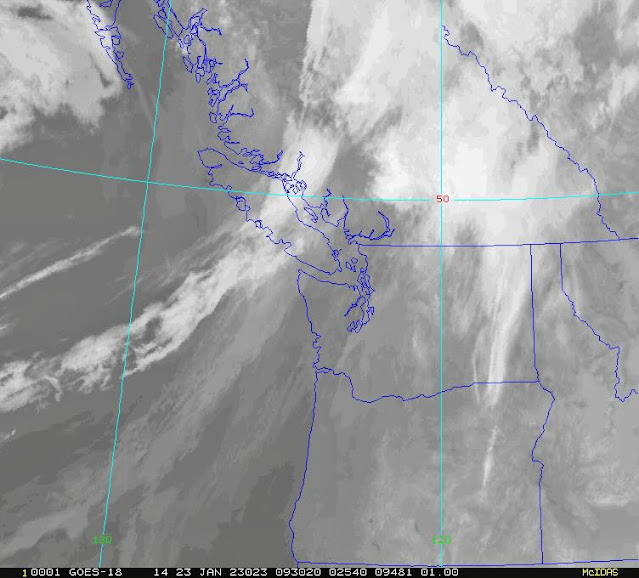
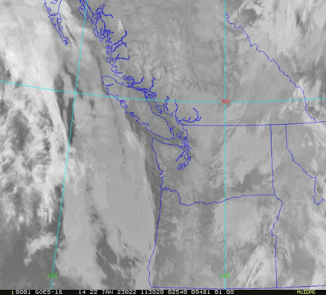
      GOES IR IMAGE from this am.


      GOES 17 ABI Image 2023/01/23. 05:00 Hrs.


          High pressure pushing but low will spill cloud into the area. Seasonable temps.


      Dirty ridging with mostly overcast skies for Monday.


      Northerly flow aloft.


      High strengthens Tuesday, but low continues to spill cloud into the area. Seasonable temps.


      Clouds for Tuesday but dry.


       High pushes inland with a mix of sun and cloud. Mostly cloudy in the pm. Inversion.


      High strengthens for Wednesday. Dry.


       High pressure slides further East on Thursday, trough arrives in the afternoon.


      Unsettled Thursday am, weak trough in the pm.


      Trough pushes South Friday with dry unsettled weather.


      Another unsettled day on Saturday.


       INFORMATION & OBSERVATIONS:

      Armchair Glacier in some early morning rising cloud.


      Mt Fee in the early morning light.

      Enjoying the soft snow.


      Glacial Moraine at the top of Fitzsimmons Valley.


      Nice effect Sunday.                                                                                               Margy Krause Image


      Clouds moved in from the South and rose as the morning progressed.


      Windy image from Sunday pm.


      More tracks on Cowboy Ridge.

      Tricouni Peak


      Awesome light as the sun started setting.


      Sun going down Sunday pm. Sunset was at 16:48 Hrs.

       Red sky at night.

      Year of the Rabbit. From Crystal Zone.                                                           Margy Krause Image


FROM AVALANCHE CANADA:


Travel and Terrain Advice

Watch for newly formed and reactive wind slabs as you transition into wind affected terrain.

Recent wind has varied in direction so watch for wind slabs on all aspects.

Avoid shallow, rocky areas where the snowpack transitions from thick to thin.


MODERATE--SEA TO SKY ADVISORY AVAILABLE TOP RIGHT SIDEBAR.


LOCAL MIN REPORTS:


Hollyburn & Christmas Gully: Jan 22, 2023

Flute Mellow Tour: Jan 22, 2023

Shannon Basin Tree Triangle: Jan 22, 2023

Sunday Elfin Tour: Jan 22, 2023

Disease and Body Bag: Jan 22, 2023

Seymour Mt Madness: Jan 22, 2023


SHORT CLIPS:

Avalanche Control, Monashee's: Avalanche Canada

Performing a kick turn: Steep Terrain

Telail Gurezz Avalanche: Kashmir

Pow Town: Sled Turns


ARTICLES:

Numerous large avalanches near Valemount: Avalanche Canada

Snowmobiler from Alberta dead from avalanche near Valemount, B.C.: CBC News

Avalanche hits Bandipara's Tulail Village: Kashmir

Two ski tourer's sustain injuries after getting caught in an avalanche in South Lake Tahoe avalanche: Heavenly

More information on the ski instructor killed by an avalanche in Les Arcs: Pistehors.com


      If you enjoy the content and find it useful, please hit the donate button, top right on side bar.


Send me recent avalanche images. E-Mail top right of the side bar. Read Below:


Goggle contest returning again this year, win a pair of Marker goggles for the best avalanche image for the months of November-January, February-March,April-May.  Grand prize best image of the  season will be a Pair of Prior Skis or a Split Board awarded at the end of May. 

22 Jan 2023

January 22, 2023

          AVALANCHE ACTIVITY: 

          An avalanche on Kornock Ski Area AT, has killed a man. Article Below.  RMR Image


      Sz 2 Sa in Aspen Area, CO. 2023/01/20. Click> CAIC Report                    Sammy Podhurst Image


       Update on 2 climbers missing, avalanche may have buried them in a crevasse. Article below.


      Sa Sz 2 NW face Mt Pattison. 2023/01/20. Click> MIN Report.                 Backcountryfruits Pic


      Minimal AC Sunday am on Whistler. Cornice trimming. Xc Sz 2. Sc Sz 1 pockets of storm slab.


     Minimal control work, on Blackcomb. Xc Bushrat. Keeping the entrances trimmed. Xc Sz 1 Sc Sz 1.


      WEATHER YESTERDAY:

      Sunrise Saturday was at 08:00 Hrs. -3 Deg c with a 15-40 KPH South wind at 1835 m.

      10:00 Hrs Saturday. -4 Deg c with a 25-40 KPH ESE wind at 1835 m.

      Saturday January 21, 2023. 12:00 Hrs. -5Deg C with a 15-35 KPH SE wind at 1835 m. S-1

      This image from the same time frame as above image.


     14:00 Hrs. -3 Deg C with a 10-20 KPH SSW wind at 1860 m.

     16:00 Hrs. -4 Deg C with a 0-5 KPH SSW breeze at 1860 m.


Weather Observations for January 22, 2023 taken at 06:00 Hours.

2280 meters     -9, Winds were 15-20 KPH ENE--Horstman Hut
2180 meters     -8, Winds were 15-25 KPH ENE--Whistler Peak
1860 meters     -8, Winds were   5-10 KPH ENE--Rendezvous  
1835 meters     -7, Winds were   0-10 KPH NE--Round House
1650 meters     -6, trace in 12 Hrs,  9 cm in 24 Hrs. Base 195 cm--Pig Alley
1570 meters     -6, 1 cm in 12 Hrs,   7 cm in 24 Hrs. Base 134 cm--Catskinner
  660 meters     -2, Valley Temp, Max temp Yesterday was +0.6, 6.1 mm of precip yesterday.


      As of 06:00 Hrs this am, we have a trace of new snow. 0.2 mm in the precip gauge. Base  195 cm.


      As of 07:00 Hrs we have overcast skies and unlimited visibility.


FORECAST:

Dirty ridging with unsettled weather for today in a Northerly flow aloft. The FL is below surface and could go as high as 1000 m today. Some morning sunny breaks with increasing cloud as the day progresses. Weak impulse early Tuesday am, with mostly overcast skies and slightly warmer temperatures. Unsettled weather Wednesday, ridge strengthens pushing inland with inverted temperatures . Mostly sunny. Pacific frontal band for Thursday with periods of light precipitation. Some models are not calling for this frontal band, time will tell! more on that as we get closer.  Unsettled Friday with a mix of sun and cloud, showers later in the day. Unsettled and much colder for Saturday. Guesstimates: trace-2 cm by Monday am, trace-2 cm by Tuesday am, 0 cm by Wednesday am, trace-2 cm by Thursday am, 8-12 cm by Friday am, trace-2 cm by Saturday am, 0 cm by Sunday am.


      GOES IR IMAGE from this am.


      GOES 17 ABI Image, 2023/01/22. 05:00 Hrs.
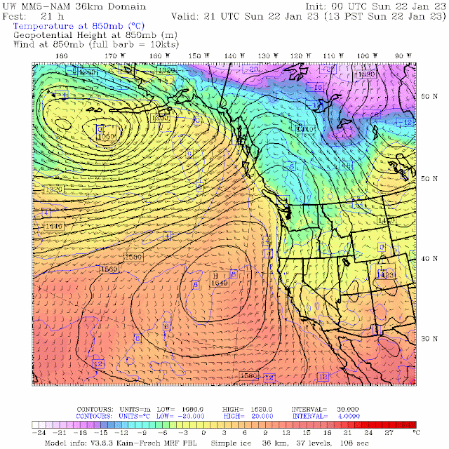

      Dirty ridging for Sunday with unsettled weather in the am, overcast in the pm. Cool temps.
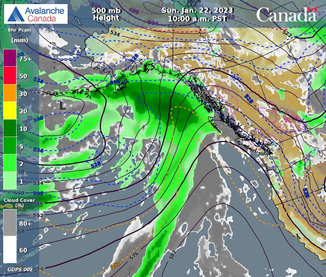

      Not much moisture, possible snow flurries Sunday. 
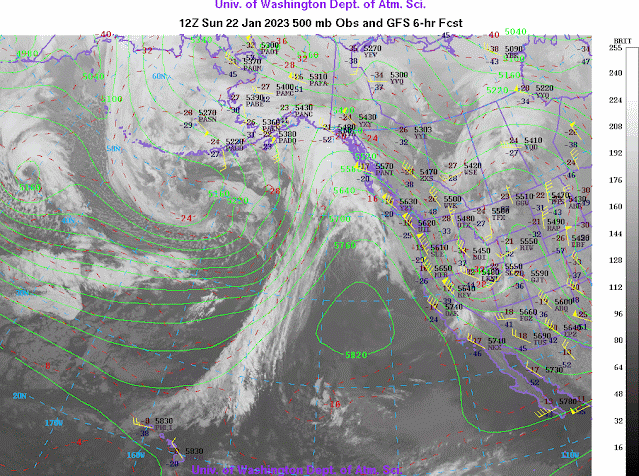

      Northerly flow aloft.
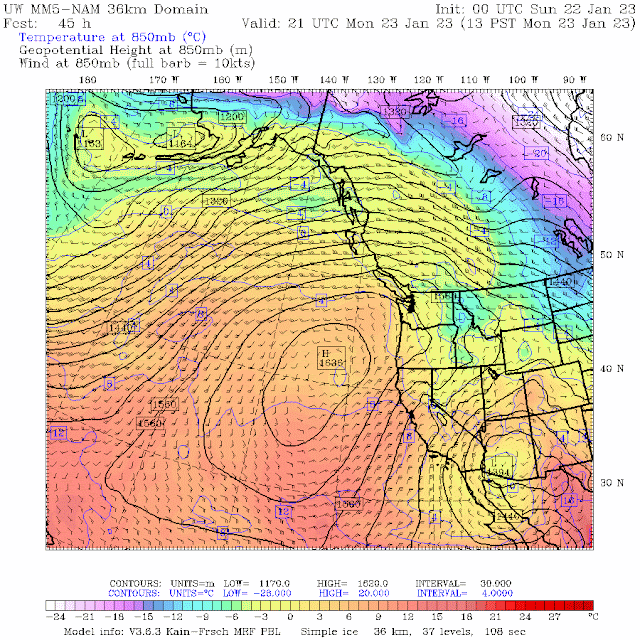


      High tries to push in, low sends a bit of moisture. Unsettled and a bit warmer.


      Early morning snow showers. Unsettled with mostly overcast skies. Likely pm sunny breaks.
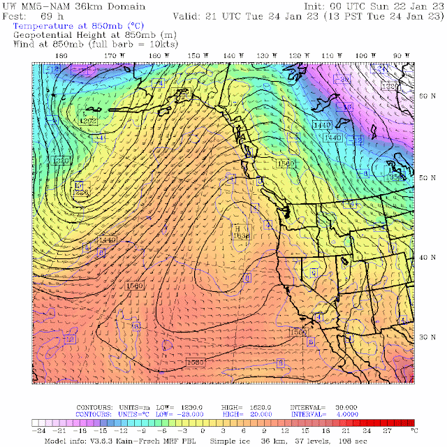


            High keeps pushing in, early am impulse from low Tuesday. Above seasonable temperatures.
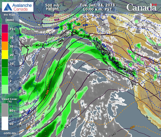

      Weak am impulse, mostly overcast Tuesday.


            High pressure strengthens, mostly sunny with some cloud. Above average temperatures. 


      High pushes inland, dry unsettled weather Wednesday. Inverted temperatures.


      High may flatten Thursday, low may send moisture our way Thursday. Perhaps this may be right!


       Unsettled weather Friday. Mix of sun and cloud lingering cloud and moisture from Thursday.


       INFORMATION & OBSERVATIONS:

     Before the cold front arrived Saturday, some nice early am light. 07:30 Hrs.


      Started snowing in the valley around 08:30 Hrs.


      It was snowing 2 cm/hr for a while in the am.

      Snowing and blowing at the Roundhouse Saturday am. 20-45 KPH in the am at 1835 m.

      On an adventure!!


      11:00 Hrs. All lifts, all zones!!


      Border Cross course on Blackcomb Saturday.


      Great turns to the valley.


      Clouds thinned, flurries at 15:00 Hrs.


      Whiplash!

     16:00 Hrs descending into the lifting mid mountain cloud!


      Sad Sign!


FROM AVALANCHE CANADA: 

Travel and Terrain Advice

Avoid shallow, rocky areas where the snowpack transitions from thick to thin.

Watch for newly formed and reactive wind slabs as you transition into wind affected terrain.


MODERATE--Sea to Sky Advisory top right of side bar.


LOCAL MIN REPORTS:

Vantage Trees: Jan 21, 2023

Seymour: Jan 21, 2023

Oboe Creek/Flute Cruiser: Jan 20, 2023


SHORT CLIPS:

Backcountry Conditions Report: MSAA

What not to do: Sledding

Nailing: Air Jordan

Aggressive Moose: Alaska Sledding Hazards

Nice Air: Nice Snow


ARTICLES: 

22 year old dies in an avalanche off piste on Kornock Ski Area: Austria (may need google translator)

Second officer dies after avalanche near Kaslo on Jan 9, 2023: Nelson, B.C.

Mountaineers missing after avalanche swept them into a crevasse: Patagonia 

Ice climbers and mountain adventurers fear climate change creates new unpredictable risks: CBC News

Stable snowpack, low avalanche danger creates great Backcountry Skiing: Utah


      If you enjoy the content and find it useful, please hit the donate button, top right on side bar.


Send me recent avalanche images. E-Mail top right of the side bar. Read Below:


Goggle contest returning again this year, win a pair of Marker goggles for the best avalanche image for the months of November-January, February-March, April-May.  Grand prize best image of the  season will be a Pair of Prior Skis or a Split Board awarded at the end of May.