17 Nov 2022

November 17, 2022

      AVALANCHE ACTIVITY:

      Sz 1 Snowmobile remote 2022/11/15. Hatcher Pass AK. Click> 
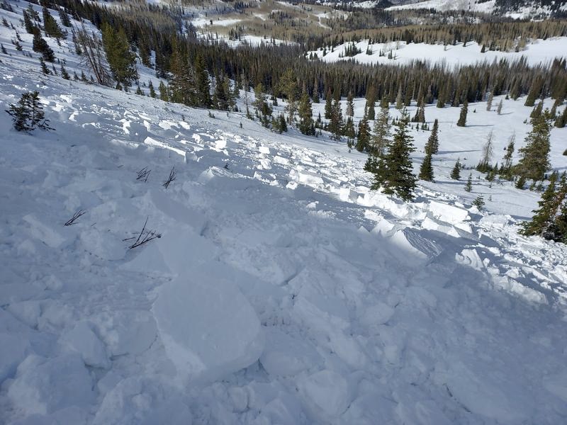
CNFAIC Report

      Mineral  Fork Glide Crack, Utah. 2022/11/15. Changing conditions in article below.  Steve Pic  

      Conditions can change quickly even in early winter. Utah.   Article below.             Antenucci Pic

       Sc Sz 1 2022/11/15. Schofield Pass, CO. Click here> CAIC Report.                           CAIC Pic


     WEATHER IN THE PAST THREE DAYS :

      Monday November 14, 2022. 12:00 Hrs. +5 C with a 5-10 KPH SE breeze. +2 at 2180 m.


      Tuesday November 15, 2022. 12:00 Hrs. +9 Deg C with a 5-10 KPH NE breeze. + 6 at 2180 m.

      Wednesday November 16, 2022. 12:00 Hrs. +8 Deg C with a 0-5 KPH SE breeze. +1 at 660 m.


Weather Observations for November 17, 2022 taken at 06:00 Hours.

2180 meters  -11, Winds were 30-50 KPH N--Whistler Peak 
1835 meters    -9, Winds were 10-30 KPH NNW--Round House
1650 meters    -7, 0.0 mm in 12 Hrs, 0.0 mm in 24 Hrs. Base  54 cm --Pig Alley
  660 meters   +2, Valley Temp, Max temp Yesterday was +2.1, 0.0 mm of precip yesterday.
 

       As of 07:00 Hrs this am we have clear skies and unlimited visibility.


FORECAST:

Strong upper level ridge continues to block any moisture from arriving on the South Coast in a Northerly flow aloft. Mostly sunny skies into Saturday am with cooler temperatures. Snow making will be able to go back into production! No more inversion for now.  Precipitation will arrive by early next week with slightly warmer than desirable temperatures and will transition to above seasonable temperatures by opening day. Several weak storms will bring snow to the alpine and to mid station prior to Thursday. More storms with warmer temperatures will follow. Hopefully there will not be a pineapple express! Guesstimates: 0 mm into Sunday am., 0-2 mm by Monday am,  4-8 mm by Tuesday am. More on the amounts and freezing levels in Mondays post. 


      GOES IR Image from this am.


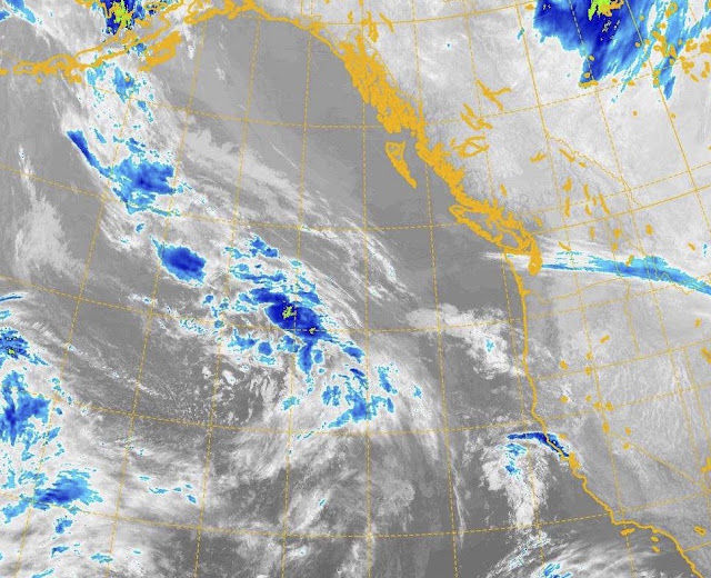
      GOES 17 ABI Image 2022/11/17. 05:00 Hrs.


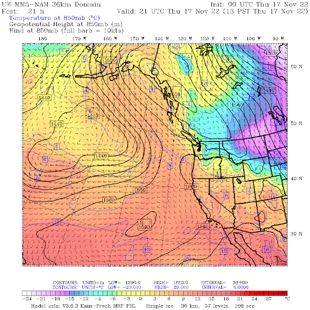
      Upper level ridge will bring sunny skies for Thursday, cooler temps.


      Upper ridge dominant feature, sunny skies for Thursday.


      Northerly flow aloft. Outflows in the coastal sounds.

       High dominating, cooler temperatures from arctic air spilling into our zone on Friday.

      Upper level ridge for Friday, sunny skies.


      Ridge holds, slightly warmer Saturday with some cloud pushing in by the pm.


      Low begins to exert some pressure on high Saturday, clouds moving down the coast.


      Dry but cloudy for Sunday.

       Ridge shifts East, series of troughs starting Monday. Weak AR event Wednesday/Thursday?

      Light precipitation on Monday, warmer.


      More precipitation on Tuesday. 

       Active storm cycle forecasted for next week into the weekend. European Model. 


      INFORMATION & OBSERVATIONS:

      If you find this blog useful please hit the donate button top of the sidebar!!


      Looks like there was a rockslide on Upper Disease Ridge. Monday.                                 WF Pic

      Track on Lower Disease Ridge.                                                                                            WF Pic


      Some cool Pacific troughs needed. Hopefully early next week with some punch!!


      Lost Lake Crystals.                                                                                                                  WF Pic

    Sunrise Tuesday 07:25 Hrs. + 4 Deg C at 2280 m with a 30-40 KPH NNE wind. -5 Deg C at 660 m


    Sunset was at 16:28 Hrs Tuesday. +5 Deg C with a 20-25 KPH North wind. -2 Deg C at 660 m.


      Frosty by Lost Lake  Wednesday am.                                                                              WF Pic

      Some interesting crystals.                                                                                             WF Pic

      Green on East side, white on West side.


      Sunset Wednesday, 16:27 Hrs. Sunrise was at 07:27 Hrs. Exactly 9 hrs. -3 Minutes from Tuesday.


LOCAL MIN REPORTS:

Sproattalicious: Nov 13, 2022

Round Mountain Sunday: Nov 13, 2022

Panorama Ridge: Nov 13, 2022


VIDEOS:

Small slide in Quebec 2022/11/14: Avalanche Quebec

Avalanche above Camp 2: Annapurna

Big Air to: Rag Doll

Brutal Lineups on opening day: Solitude

Snowpack in Montana: MTavalanche

Mitigating Avalanche Risk in High Mountain Asia: Cryosphere


ARTICLES:

How to learn from avalanche accident reports: Powder Cloud

How quickly the avalanche conditions can change: Utah

Turbocharge your trailhead beacon check: WildSnow

Significant cooling event in the Southern Hemisphere, volcanic influence:  Severe Weather Europe 

Vail Resorts stamping out on those leaving their equipment to reserve place: SnowBrains


14 Nov 2022

November 14, 2022

      AVALANCHE ACTIVITY:

      Skier Accidental Hard Slab. Wolf Creek Utah. 2022/11/12. UAC Report.    Michael Janulaitis Pic

      Skier Triggered Hard slab, Marmot-Hatcher Pass, AK. CNFIAC Report.    Austin Hart Image?

      Sz 2 Na Galena Peak, Idaho. 2022/11/10 Click for report> SAC Report                         SAC Pic


      Skier accidental Flagstaff Ridge, Utah. 2022/11/10. UAC Report.               Bellamy/Pearson Pic

      Sa Sz 1Alpine Meadows area, Calif. 2022/11/09. SAC Report.                                     SAC Pic


      Skier remote on Mount Blackmore, Montana. 2022/11/09.  GNFAC Report                GNFAC pic


      WEATHER IN THE PAST FEW DAYS:

      Thursday November 10, 2022. 12:00 Hrs. -8 Deg C with a 0-5 KPH NNW Breeze.


      Friday November 11, 2022. 12:00 Hrs. -2 Deg C with a 10-20 KPH ESE wind.


      Saturday November 12, 2022. 12:00 Hrs. -1 Deg C with a 5-10 KPH WNW Breeze.


     Sunday November 13, 2022. 12:45 Hrs. +1 Deg C with a 5-10 KPH NNE breeze.


Weather Observations for November 14, 2022 taken at 06:00 Hours.

2180 meters     0, Winds were 30-50 KPH N--Whistler Peak 
1835 meters   +1, Winds were   5-20 KPH N--Round House
1650 meters    -1, 0.0 mm in 12 Hrs, 0.0 mm in 24 Hrs. Base 58 cm. --Pig Alley
  660 meters    -1, Valley Temp, Max temp Yesterday was +5.4, 0.0 mm of precip yesterday. 


     As of 07:00 Hrs we have some high broken thin cloud, unlimited visibility and a slight inversion.


FORECAST:

High amplitude ridge bringing an omega block, will dominate the weather pattern for the rest of the week. For today we can expect sunny skies, in a Northerly flow aloft with warm temperatures. Some thin high cloud this am should burn off quickly. Sunny conditions with some occasional cloud will be with us until at least Sunday, when we should see colder temperatures, increasing cloud cover and a flattening ridge. Hopefully the moisture train returns Monday with some much needed snow. Time will tell!! More on the forecast in Thursday's post (Nov 17). Guesstimates: no snow until at least Sunday/Monday. 


      GOES IR Image from this am.


      GOES 17 ABI image 2022/11/14. 05:00 Hrs.


       Omega Block bringing dry sunny weather during a typically wet period for mid November.


       Sunny skies with a strong ridge of high pressure dominating the weather pattern. Warm!

      Omega Block with dry warmish weather for Monday. Very unusual pattern for this time of year!


      Northerly flow aloft for today.


       Dry sunny weather for Tuesday, continues to be warmer than seasonable.


      High strengthening Tuesday.


       High continues to be dominant force on Wednesday. Still on the warm side.


      High pressure deflecting low on Wednesday. may see some cloud.


      High pressure Thursday with some cooler air from the interior.


      Massive high all the way up the BC coast Thursday.


      No sign of breaking down on Friday. Massive low may start pushing back.

     INFORMATION & OBSERVATIONS:

      Stratus layer lifting by 09:00 Hrs Thursday. -7 Deg C with a 5-10 KPH South breeze at 1860 m.


      Cloudy Thursday afternoon. High in the valley was -1 Deg C.                                           WF Pic


      Snow making on Lower Ptarmigan, Thursday.                                                                    WF Pic

      Thursday 15:00 Hrs. -3 Deg C with a 10-15 KPH South wind at 2280 m..

      Sunrise Friday, 07:18 Hrs. -6 Deg C with a 0-10 KPH North breeze. 1 cm recorded at 1650 m.

      Pushing man made snow on Zig Zag.                                                                                WF Pic

      Bushrat, Saturday around 12:00. -3 Deg C with a calm wind at 2280 m.                               WF Pic


      Massive high will bring dry weather for the foreseeable future. Image from Saturday pm.

      Slowly clearing out South of Whistler.  Saturday noon.

      Clear to the South West. 17:00 Hrs. -5 Deg C wit a 5-10 KPH North breeze @ 2280 m..

      Sunset Saturday was at 16:32 Hrs. Red sky at night, sailors delight. Not!!! No snow for a while!!!

     Sunday sunrise was at 07:22 Hrs. -6 Deg C with a 40-50 KPH North wind at 2280 m.

      Hoar Frost< click,  in the valley Sunday am.                                                                       WF pic


      Track packing on Gandy Dancer/Ross's Gold. Image taken Sunday afternoon.                  WF Pic

      Enjoying the snow, high in the valley Sunday was +5.4 Deg C.

      18:00 Hrs Sunday. -2 Deg C with a 40-50 KPH NNE wind. -2 in the valley.

      Windy image from same time frame as above.


LOCAL MIN REPORTS:

Panorama: Nov 13, 2022

Quiet day on Shovelnose: : Nov 12, 2022

Gin Peak: Nov 12, 2022

Things are changing: Nov 12, 2022

Suffering in the Coast Mountains: Nov 12, 2022

Opal Cone Ring Creek: Nov 11, 2022

Black Tusk: Nov 11, 2022

Alpen Mountain: Nov 11, 2022

Brockton: Nov 11, 2022

Rethel Couloir: Nov 9, 2022


VIDEOS:

Cornice Collapse: Very Lucky

Sled gets caught high marking: AvyBites

Cornices and slabs: AvyBites

Large Avalanche: Denali

Sz 1 Storm Slab: AvyBites

Nasty Ride: MSP Films


ARTICLES:

How consistent is that avalanche advisory: Outside

Tips for safe early season backcountry skiing: Blackbird Mountain Guides

Avalanche season is here: Montana

CDOT aims for more distant avalanche control by reloading gas exploders: Colorado

La Nina Advisory-ENSO Diagnostic Discussion: NOAA

Avalanche Problems: EAWS

Vernon SAR has tips for people venturing into the Backcountry: B.C.