AVALANCHE ACTIVITY:
Two more avalanche deaths in France. Article below. File photo from Pisthors.com
Skier Remote Front Range, Co. 2022/11/07. Click for report-
CAIC CAIC Pic
Cornice drop, Sz 2 slab 2022/11/03. New Zealand. Facebook report here-
NZAA
WEATHER IN THE PAST WEEK:
Monday November 7, 2022. 12:00 Hrs. -13 Deg C with a 5-20 KPH NNW wind. Fog or ice?
12:00 Hrs Monday from 2280 m. -14 Deg C with a 15-30 KPH East wind.
Tuesday November 8, 2022. 12:00 Hrs. -11 Deg C with a 10-20 KPH NNE wind.
Wednesday November 9, 2022. 12:00 Hrs. -3 Deg C with a 0-5 KPH SE breeze.
Weather Observations for November 10, 2022 taken at 06:00 Hours.
2180 meters -10, Winds were 20-30 KPH W--Whistler Peak
1835 meters -6, Winds were 5-10 KPH S--Round House
1650 meters -11, 0.0 mm in 12 Hrs, 0.0 mm in 24 Hrs, Base 62 cm --Pig Alley
660 meters -8, Valley Temp, Max temp Yesterday was -2.5, 0.0 mm of precip yesterday.
As of 07:00m Hrs Thursday Nov 10th, we have a stratus layer with unlimited visibility above 1500 m.
FORECAST:
Unfortunately the dry weather will continue into early next week. For today we can expect an increase in cloud as a weak front moves down the coast in a Northerly flow aloft. Stratus cloud layer has already moved into inland valleys. Overcast conditions with cool temperatures later today. The flow aloft switches to Westerly later in the day. Friday will see a chance of some showers but looks pretty dry. Dirty ridging for the weekend with mostly sunny skies with some cloud in the mix. More of the same early next week. Will post again on Monday. Guesstimates: 0 mm by Friday am, 0-1 mm by Saturday am. 0 mm for Sunday into next week. May see some precipitation Friday Nov 18, 2022.???? It can change!!
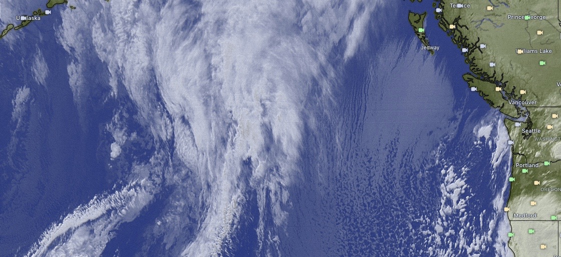
GOES IR Image from this am.
GOES 17 ABI Image 2022/11/10. 05:00 Hrs.
Stratus Layer has moved inland, low moving down the coast Thursday. Warmer!

Stratus cloud has moved into coastal valleys, no precipitation for Thursday.
Northerly flow aloft for most of Thursday.
Low well off the coast, overcast with chance of some showers Friday.
Most of the moisture is well off the coast Friday. Overcast with slight chance of a shower.
Dirty ridging for Saturday with a mix of sun and cloud, slightly below seasonable temperatures.
Low well too the South, dry unsettled weather for Saturday.
Weak high for Sunday with a mix of sun and cloud. Cool temperatures.
Unsettled Sunday with no precipitation. Blocking pattern as high is in control.
Dry Monday with ridging still in control.
INFORMATION & OBSERVATIONS:
Snowmaking on Whistler Monday was creating a moist cloud obscuring the roundhouse camera.
Cold temperatures in the valley Monday, Low of -8 Deg C with a brisk North outflow.
Still hungry bears in the valley.
Tuesday am, arctic high well established over Whistler. -10 at 660 m 06:00 Hrs.
Sunrise Tuesday 07:13 Hrs. -16 Deg C with a 10-30 KPH NE wind. -27 wind chill at 30 KPH.
River of Golden dreams is freezing up above the dam by Meadow Park.
Track Packing on Chocker. Tuesday Afternoon.
Wind slab in the valley! Wind transport off Green Lake Tuesday.
Surprisingly good riding on trails.
Sunrise Wednesday 07:15 Hrs. -10 Deg C with a 15-20 KPH North wind.
High pressure over much of BC Wednesday am. GOES 17 ABI image.
Rumbling Glacier Wednesday.
Mount Fee, Different perspective.
Windy Image Wednesday night. Weak front will bring some cloud to our zone Today.


.jpg)


